Huanuara geodata
Huanuara (Tacna) is a seat of a third-order administrative division; located in Peru in America/Lima (GMT-5) time zone. In our database, there are 305 cities with bigger population. Compared to other cities in Peru, 98.1% of cities are located further ↑North; 93.9% of cities are located further ←West and 63.9% of cities have lower elevation than Huanuara. Note1


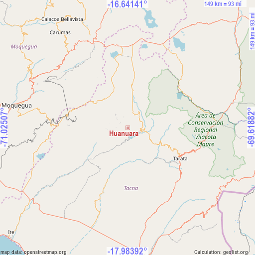
Huanuara GPS coordinates[2]
17° 18' 50.004" South, 70° 19' 18.984" West
| Map corner | latitude | longitude |
|---|---|---|
| Upper-left | -16.64141°, | -71.02507° |
| Center: | -17.31389°, | -70.32194° |
| Lower-right: | -17.98392°, | -69.61882° |
| Map W x H: | 149.3×149.3 km | = 92.8×92.8mi |
| max Lat: | -0.96667° ⇑98.1% North |
| Huanuara: | -17.31389° |
| min Lat: | ⇓1.9% South -18.01465° |
| min Long | Huanuara | max Long |
| -81.30472° | -70.32194° | -69.04167° |
| W 93.9%⇐ | ⇒6.1% E |
Elevation
Elevation of Huanuara is 3244 m = 10643 ft, and this is 925.3 m = 3036 ft above average elevation for this country.
| Max E: |
5022 m = 16476 ft | 36.1% |
| Huanuara | 3244 m 10643 ft | |
| Avg. | 2318.7 m = 7607 ft | |
Min E: |
1 m = 3 ft | 63.9% |
See also: Peru elevation on elevation.city.
Geographical zone
Huanuara is located in South Torrid zone (between Equator and Tropic of Capricorn). Distance of this Southern Tropic circle is 680.8 km =423 mi to South.| Distance of | km | miles | from Huanuara |
|---|---|---|---|
| Equator | 1925.1 | 1196.2 | to North |
| Tropic Capricorn | 680.8 | 423 | to South |
| Antarctic Circle | 5476 | 3402.6 | to South |
| South Pole | 8081.9 | 5021.9 | to South |


Nearby cities:
15 places around Huanuara: (largest is in red/bold)
• Cairani
5.4 km =3.4 mi,  305°
305°
• Camilaca
7.8 km =4.8 mi, 310°
• Candarave
9.2 km =5.7 mi,  56°
56°
• Chipispaya
23.3 km =14.5 mi,  151°
151°
• Chucatamani
28.1 km =17.5 mi,  131°
131°
• Chuquitira
29.7 km =18.5 mi,  84°
84°
• Curibaya
7.7 km =4.8 mi,  190°
190°
• Ilabaya
23.5 km =14.6 mi,  239°
239°
• Pujocucho
17.7 km =11 mi,  349°
349°
• Quilahuani
6.8 km =4.2 mi,  93°
93°
• Sitajara
21.3 km =13.2 mi,  108°
108°
• Susapaya
20.6 km =12.8 mi,  102°
102°
• Tarata
35.5 km =22.1 mi,  120°
120°
• Ticaco
32.7 km =20.3 mi, 116°
• Totoral
11.2 km =7 mi,  203°
203°
Sources, notices
• [Note1] Compared only with cities in Peru existing in our database
• [Src1] Map data: © OpenStreetMap contributors (CC-BY-SA)
• [Src2] Other city data from geonames.org with taken over terms of usage.
• [Src3] Geographical zone / Annual Mean Temperature by Robert A. Rohde @ Wikipedia
