Candarave geodata
Candarave (Tacna) is a seat of a third-order administrative division; located in Peru in America/Lima (GMT-5) time zone. With population of 3,415 people, there are 292 cities with bigger population in this country. Compared to other cities in Peru, 97.8% of cities are located further ↑North; 94.3% of cities are located further ←West and 75.8% of cities have lower elevation than Candarave. Note1


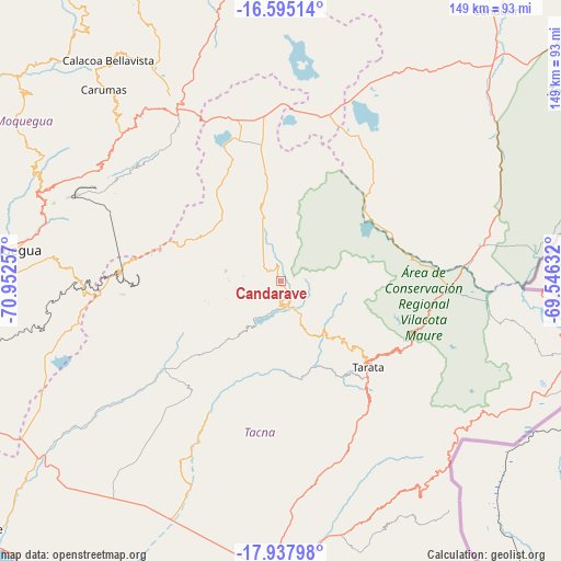
Candarave GPS coordinates[2]
17° 16' 4.008" South, 70° 14' 57.984" West
| Map corner | latitude | longitude |
|---|---|---|
| Upper-left | -16.59514°, | -70.95257° |
| Center: | -17.26778°, | -70.24944° |
| Lower-right: | -17.93798°, | -69.54632° |
| Map W x H: | 149.3×149.3 km | = 92.8×92.8mi |
| max Lat: | -0.96667° ⇑97.8% North |
| Candarave: | -17.26778° |
| min Lat: | ⇓2.2% South -18.01465° |
| min Long | Candarave | max Long |
| -81.30472° | -70.24944° | -69.04167° |
| W 94.3%⇐ | ⇒5.7% E |
Elevation
Elevation of Candarave is 3445 m = 11302 ft, and this is 1126.3 m = 3695 ft above average elevation for this country.
| Max E: |
5022 m = 16476 ft | 24.2% |
| Candarave | 3445 m 11302 ft | |
| Avg. | 2318.7 m = 7607 ft | |
Min E: |
1 m = 3 ft | 75.8% |
See also: Peru elevation on elevation.city.
Geographical zone
Candarave is located in South Torrid zone (between Equator and Tropic of Capricorn). Distance of this Southern Tropic circle is 685.9 km =426.2 mi to South.| Distance of | km | miles | from Candarave |
|---|---|---|---|
| Equator | 1920 | 1193 | to North |
| Tropic Capricorn | 685.9 | 426.2 | to South |
| Antarctic Circle | 5481.2 | 3405.9 | to South |
| South Pole | 8087.1 | 5025.1 | to South |


Nearby cities:
15 places around Candarave: (largest is in red/bold)
• Cairani
12.3 km =7.6 mi,  260°
260°
• Camilaca
13.7 km =8.5 mi,  269°
269°
• Chipispaya
25.8 km =16 mi,  172°
172°
• Chucatamani
27.2 km =16.9 mi,  150°
150°
• Chuquitira
22 km =13.7 mi,  96°
96°
• Curibaya
15.6 km =9.7 mi,  215°
215°
• Huanuara
9.2 km =5.7 mi,  236°
236°
• Ilabaya
32.8 km =20.4 mi, 238°
• Pujocucho
16.4 km =10.2 mi,  318°
318°
• Quilahuani
5.6 km =3.5 mi,  189°
189°
• Sitajara
17.3 km =10.7 mi,  133°
133°
• Susapaya
15.7 km =9.8 mi, 127°
• Tarata
32.5 km =20.2 mi, 134°
• Ticaco
29.3 km =18.2 mi, 132°
• Totoral
19.7 km =12.2 mi, 218°
Sources, notices
• [Note1] Compared only with cities in Peru existing in our database
• [Src1] Map data: © OpenStreetMap contributors (CC-BY-SA)
• [Src2] Other city data from geonames.org with taken over terms of usage.
• [Src3] Geographical zone / Annual Mean Temperature by Robert A. Rohde @ Wikipedia
