Susapaya geodata
Susapaya (Tacna) is a seat of a third-order administrative division; located in Peru in America/Lima (GMT-5) time zone. In our database, there are 305 cities with bigger population. Compared to other cities in Peru, 98.3% of cities are located further ↑North; 95.4% of cities are located further ←West and 72.4% of cities have lower elevation than Susapaya. Note1


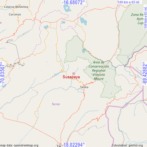
Susapaya GPS coordinates[2]
17° 21' 11.016" South, 70° 7' 54.984" West
| Map corner | latitude | longitude |
|---|---|---|
| Upper-left | -16.68072°, | -70.83507° |
| Center: | -17.35306°, | -70.13194° |
| Lower-right: | -18.02294°, | -69.42882° |
| Map W x H: | 149.2×149.2 km | = 92.7×92.7mi |
| max Lat: | -0.96667° ⇑98.3% North |
| Susapaya: | -17.35306° |
| min Lat: | ⇓1.7% South -18.01465° |
| min Long | Susapaya | max Long |
| -81.30472° | -70.13194° | -69.04167° |
| W 95.4%⇐ | ⇒4.6% E |
Elevation
Elevation of Susapaya is 3386 m = 11109 ft, and this is 1067.3 m = 3502 ft above average elevation for this country.
| Max E: |
5022 m = 16476 ft | 27.6% |
| Susapaya | 3386 m 11109 ft | |
| Avg. | 2318.7 m = 7607 ft | |
Min E: |
1 m = 3 ft | 72.4% |
See also: Peru elevation on elevation.city.
Geographical zone
Susapaya is located in South Torrid zone (between Equator and Tropic of Capricorn). Distance of this Southern Tropic circle is 676.4 km =420.3 mi to South.| Distance of | km | miles | from Susapaya |
|---|---|---|---|
| Equator | 1929.5 | 1198.9 | to North |
| Tropic Capricorn | 676.4 | 420.3 | to South |
| Antarctic Circle | 5471.7 | 3400 | to South |
| South Pole | 8077.6 | 5019.2 | to South |


Nearby cities:
15 places around Susapaya: (largest is in red/bold)
• Cairani
25.7 km =16 mi,  286°
286°
• Camilaca
27.8 km =17.3 mi, 289°
• Candarave
15.7 km =9.8 mi,  307°
307°
• Chipispaya
18.5 km =11.5 mi,  209°
209°
• Chucatamani
14.2 km =8.8 mi,  175°
175°
• Chuquitira
11.8 km =7.3 mi,  52°
52°
• Curibaya
21.8 km =13.5 mi,  261°
261°
• Estique
24.2 km =15 mi,  150°
150°
• Huanuara
20.6 km =12.8 mi,  282°
282°
• Quilahuani
13.9 km =8.6 mi, 286°
• Sitajara
2.5 km =1.6 mi, 180°
• Tarata
17.1 km =10.6 mi,  142°
142°
• Tarucachi
22 km =13.7 mi, 150°
• Ticaco
13.7 km =8.5 mi, 139°
• Totoral
25.4 km =15.8 mi, 256°
Sources, notices
• [Note1] Compared only with cities in Peru existing in our database
• [Src1] Map data: © OpenStreetMap contributors (CC-BY-SA)
• [Src2] Other city data from geonames.org with taken over terms of usage.
• [Src3] Geographical zone / Annual Mean Temperature by Robert A. Rohde @ Wikipedia
