Ilabaya geodata
Ilabaya (Tacna) is a seat of a third-order administrative division; located in Peru in America/Lima (GMT-5) time zone. With population of 9,492 people, there are 146 cities with bigger population in this country. Compared to other cities in Peru, 98.6% of cities are located further ↑North; 92.6% of cities are located further ←West and 70.3% of cities have higher elevation than Ilabaya. Note1


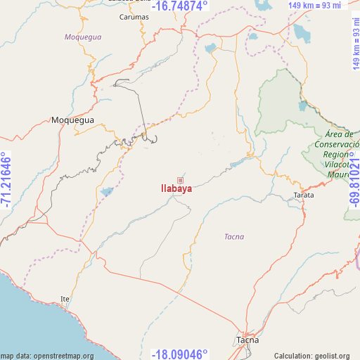
Ilabaya GPS coordinates[2]
17° 25' 14.988" South, 70° 30' 47.988" West
| Map corner | latitude | longitude |
|---|---|---|
| Upper-left | -16.74874°, | -71.21646° |
| Center: | -17.42083°, | -70.51333° |
| Lower-right: | -18.09046°, | -69.81021° |
| Map W x H: | 149.2×149.2 km | = 92.7×92.7mi |
| max Lat: | -0.96667° ⇑98.6% North |
| Ilabaya: | -17.42083° |
| min Lat: | ⇓1.4% South -18.01465° |
| min Long | Ilabaya | max Long |
| -81.30472° | -70.51333° | -69.04167° |
| W 92.6%⇐ | ⇒7.4% E |
Elevation
Elevation of Ilabaya is 1386 m = 4547 ft, and this is 932.7 m = 3060 ft below average elevation for this country.
| Max E: |
5022 m = 16476 ft | 70.3% |
| Avg. | 2318.7 m = 7607 ft | |
| Ilabaya | 1386 m = 4547 ft | |
Min E: |
1 m = 3 ft | 29.7% |
See also: Peru elevation on elevation.city.
Geographical zone
Ilabaya is located in South Torrid zone (between Equator and Tropic of Capricorn). Distance of this Southern Tropic circle is 668.9 km =415.6 mi to South.| Distance of | km | miles | from Ilabaya |
|---|---|---|---|
| Equator | 1937 | 1203.6 | to North |
| Tropic Capricorn | 668.9 | 415.6 | to South |
| Antarctic Circle | 5464.2 | 3395.3 | to South |
| South Pole | 8070 | 5014.5 | to South |


Nearby cities:
15 places around Ilabaya: (largest is in red/bold)
• Cairani
21.9 km =13.6 mi,  46°
46°
• Camilaca
22.2 km =13.8 mi,  40°
40°
• Candarave
32.8 km =20.4 mi,  58°
58°
• Chipispaya
32.6 km =20.3 mi,  105°
105°
• Chucatamani
42 km =26.1 mi,  99°
99°
• Curibaya
19.4 km =12.1 mi,  77°
77°
• Huanuara
23.5 km =14.6 mi, 59°
• Locumba
34 km =21.1 mi,  231°
231°
• Pujocucho
33.9 km =21.1 mi,  30°
30°
• Quilahuani
29.4 km =18.3 mi,  67°
67°
• Sama Grande
41.4 km =25.7 mi,  177°
177°
• Samegua
48.9 km =30.4 mi,  303°
303°
• Sitajara
40.7 km =25.3 mi, 82°
• Susapaya
41.2 km =25.6 mi, 79°
• Totoral
15.9 km =9.9 mi, 84°
Sources, notices
• [Note1] Compared only with cities in Peru existing in our database
• [Src1] Map data: © OpenStreetMap contributors (CC-BY-SA)
• [Src2] Other city data from geonames.org with taken over terms of usage.
• [Src3] Geographical zone / Annual Mean Temperature by Robert A. Rohde @ Wikipedia
