Chipispaya geodata
Chipispaya (Tacna) is a populated place; located in Peru in America/Lima (GMT-5) time zone. With population of 1,932 people, there are 299 cities with bigger population in this country. Compared to other cities in Peru, 98.9% of cities are located further ↑North; 94.4% of cities are located further ←West and 66.2% of cities have higher elevation than Chipispaya. Note1


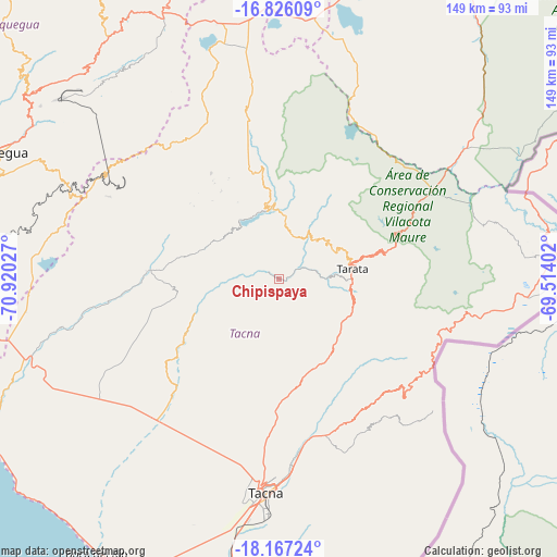
Chipispaya GPS coordinates[2]
17° 29' 52.44" South, 70° 13' 1.704" West
| Map corner | latitude | longitude |
|---|---|---|
| Upper-left | -16.82609°, | -70.92027° |
| Center: | -17.4979°, | -70.21714° |
| Lower-right: | -18.16724°, | -69.51402° |
| Map W x H: | 149.1×149.1 km | = 92.6×92.6mi |
| max Lat: | -0.96667° ⇑98.9% North |
| Chipispaya: | -17.4979° |
| min Lat: | ⇓1.1% South -18.01465° |
| min Long | Chipispaya | max Long |
| -81.30472° | -70.21714° | -69.04167° |
| W 94.4%⇐ | ⇒5.6% E |
Elevation
Elevation of Chipispaya is 1940 m = 6365 ft, and this is 378.7 m = 1242 ft below average elevation for this country.
| Max E: |
5022 m = 16476 ft | 66.2% |
| Avg. | 2318.7 m = 7607 ft | |
| Chipispaya | 1940 m = 6365 ft | |
Min E: |
1 m = 3 ft | 33.8% |
See also: Peru elevation on elevation.city.
Geographical zone
Chipispaya is located in South Torrid zone (between Equator and Tropic of Capricorn). Distance of this Southern Tropic circle is 660.3 km =410.3 mi to South.| Distance of | km | miles | from Chipispaya |
|---|---|---|---|
| Equator | 1945.6 | 1208.9 | to North |
| Tropic Capricorn | 660.3 | 410.3 | to South |
| Antarctic Circle | 5455.6 | 3390 | to South |
| South Pole | 8061.5 | 5009.2 | to South |


Nearby cities:
15 places around Chipispaya: (largest is in red/bold)
• Cairani
28.2 km =17.5 mi,  326°
326°
• Camilaca
30.7 km =19.1 mi, 326°
• Candarave
25.8 km =16 mi,  352°
352°
• Chucatamani
10.2 km =6.3 mi,  79°
79°
• Chuquitira
29.6 km =18.4 mi,  38°
38°
• Curibaya
17.9 km =11.1 mi,  315°
315°
• Estique
21.6 km =13.4 mi,  103°
103°
• Huanuara
23.3 km =14.5 mi, 331°
• Quilahuani
20.5 km =12.7 mi, 347°
• Sitajara
16.3 km =10.1 mi,  33°
33°
• Susapaya
18.5 km =11.5 mi, 29°
• Tarata
19.7 km =12.2 mi, 82°
• Tarucachi
20.2 km =12.6 mi, 98°
• Ticaco
18.9 km =11.7 mi,  72°
72°
• Totoral
18.7 km =11.6 mi,  303°
303°
Sources, notices
• [Note1] Compared only with cities in Peru existing in our database
• [Src1] Map data: © OpenStreetMap contributors (CC-BY-SA)
• [Src2] Other city data from geonames.org with taken over terms of usage.
• [Src3] Geographical zone / Annual Mean Temperature by Robert A. Rohde @ Wikipedia
