Tintay geodata
Tintay (Apurímac) is a seat of a third-order administrative division; located in Peru in America/Lima (GMT-5) time zone. In our database, there are 305 cities with bigger population. Compared to other cities in Peru, 73.2% of cities are located further ↑North; 72.3% of cities are located further ←West and 52% of cities have higher elevation than Tintay. Note1


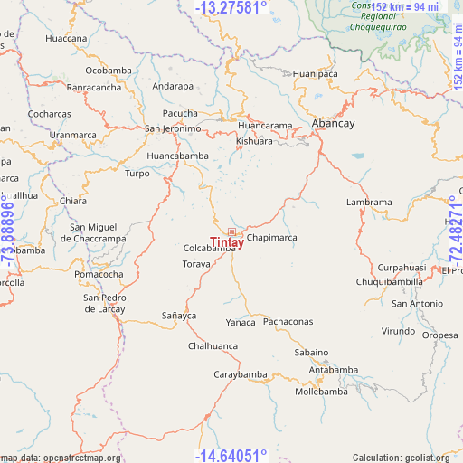
Tintay GPS coordinates[2]
13° 57' 33.012" South, 73° 11' 8.988" West
| Map corner | latitude | longitude |
|---|---|---|
| Upper-left | -13.27581°, | -73.88896° |
| Center: | -13.95917°, | -73.18583° |
| Lower-right: | -14.64051°, | -72.48271° |
| Map W x H: | 151.7×151.7 km | = 94.3×94.3mi |
| max Lat: | -0.96667° ⇑73.2% North |
| Tintay: | -13.95917° |
| min Lat: | ⇓26.8% South -18.01465° |
| min Long | Tintay | max Long |
| -81.30472° | -73.18583° | -69.04167° |
| W 72.3%⇐ | ⇒27.7% E |
Elevation
Elevation of Tintay is 2780 m = 9121 ft, and this is 461.3 m = 1513 ft above average elevation for this country.
| Max E: |
5022 m = 16476 ft | 52% |
| Tintay | 2780 m 9121 ft | |
| Avg. | 2318.7 m = 7607 ft | |
Min E: |
1 m = 3 ft | 48% |
See also: Peru elevation on elevation.city.
Geographical zone
Tintay is located in South Torrid zone (between Equator and Tropic of Capricorn). Distance of this Southern Tropic circle is 1053.8 km =654.8 mi to South.| Distance of | km | miles | from Tintay |
|---|---|---|---|
| Equator | 1552.1 | 964.4 | to North |
| Tropic Capricorn | 1053.8 | 654.8 | to South |
| Antarctic Circle | 5849.1 | 3634.5 | to South |
| South Pole | 8454.9 | 5253.6 | to South |


Nearby cities:
15 places around Tintay: (largest is in red/bold)
• Ayahuay
30.5 km =19 mi,  155°
155°
• Capaya
22.8 km =14.2 mi,  218°
218°
• Chapimarca
13.2 km =8.2 mi,  97°
97°
• Colcabamba
8.6 km =5.3 mi,  231°
231°
• Huayllo
21.2 km =13.2 mi,  204°
204°
• Kishuara
30.4 km =18.9 mi,  14°
14°
• Lucre
4.5 km =2.8 mi,  284°
284°
• Pachaconas
34 km =21.1 mi,  149°
149°
• Pichirhua
16.3 km =10.1 mi,  47°
47°
• Pocohuanca
30.7 km =19.1 mi, 158°
• Sañayca
31.9 km =19.8 mi,  210°
210°
• Soraya
26.4 km =16.4 mi, 211°
• Tapairihua
20.7 km =12.9 mi,  167°
167°
• Toraya
15.7 km =9.8 mi, 229°
• Yanaca
29.2 km =18.1 mi, 170°
Sources, notices
• [Note1] Compared only with cities in Peru existing in our database
• [Src1] Map data: © OpenStreetMap contributors (CC-BY-SA)
• [Src2] Other city data from geonames.org with taken over terms of usage.
• [Src3] Geographical zone / Annual Mean Temperature by Robert A. Rohde @ Wikipedia
