Kishuara geodata
Kishuara (Apurímac) is a seat of a third-order administrative division; located in Peru in America/Lima (GMT-5) time zone. In our database, there are 305 cities with bigger population. Compared to other cities in Peru, 70.1% of cities are located further ↑North; 72.8% of cities are located further ←West and 86.5% of cities have lower elevation than Kishuara. Note1


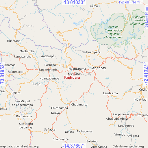
Kishuara GPS coordinates[2]
13° 41' 39.984" South, 73° 6' 59.004" West
| Map corner | latitude | longitude |
|---|---|---|
| Upper-left | -13.01033°, | -73.81952° |
| Center: | -13.69444°, | -73.11639° |
| Lower-right: | -14.37657°, | -72.41327° |
| Map W x H: | 151.9×151.9 km | = 94.4×94.4mi |
| max Lat: | -0.96667° ⇑70.1% North |
| Kishuara: | -13.69444° |
| min Lat: | ⇓29.9% South -18.01465° |
| min Long | Kishuara | max Long |
| -81.30472° | -73.11639° | -69.04167° |
| W 72.8%⇐ | ⇒27.2% E |
Elevation
Elevation of Kishuara is 3716 m = 12192 ft, and this is 1397.3 m = 4584 ft above average elevation for this country.
| Max E: |
5022 m = 16476 ft | 13.5% |
| Kishuara | 3716 m 12192 ft | |
| Avg. | 2318.7 m = 7607 ft | |
Min E: |
1 m = 3 ft | 86.5% |
See also: Peru elevation on elevation.city.
Geographical zone
Kishuara is located in South Torrid zone (between Equator and Tropic of Capricorn). Distance of this Southern Tropic circle is 1083.2 km =673.1 mi to South.| Distance of | km | miles | from Kishuara |
|---|---|---|---|
| Equator | 1522.7 | 946.2 | to North |
| Tropic Capricorn | 1083.2 | 673.1 | to South |
| Antarctic Circle | 5878.5 | 3652.7 | to South |
| South Pole | 8484.4 | 5272 | to South |


Nearby cities:
15 places around Kishuara: (largest is in red/bold)
• Abancay
26.3 km =16.3 mi,  75°
75°
• Andahuaylas
29.6 km =18.4 mi,  278°
278°
• Andarapa
32.8 km =20.4 mi,  304°
304°
• Chapimarca
31.7 km =19.7 mi,  169°
169°
• Circa
33 km =20.5 mi,  127°
127°
• Huancarama
6.4 km =4 mi,  30°
30°
• Huanipaca
29.3 km =18.2 mi,  42°
42°
• Lucre
30.7 km =19.1 mi,  202°
202°
• Pacobamba
9.3 km =5.8 mi,  20°
20°
• Pacucha
26.3 km =16.3 mi,  291°
291°
• Pichirhua
19.1 km =11.9 mi, 165°
• San Jerónimo
27.2 km =16.9 mi, 280°
• San Pedro De Cachora
26.1 km =16.2 mi,  74°
74°
• Tamburco
27.8 km =17.3 mi, 71°
• Tintay
30.4 km =18.9 mi,  194°
194°
Sources, notices
• [Note1] Compared only with cities in Peru existing in our database
• [Src1] Map data: © OpenStreetMap contributors (CC-BY-SA)
• [Src2] Other city data from geonames.org with taken over terms of usage.
• [Src3] Geographical zone / Annual Mean Temperature by Robert A. Rohde @ Wikipedia
