Pucara geodata
Pucara (Arequipa) is a populated place; located in Peru in America/Lima (GMT-5) time zone. With population of 4,335 people, there are 256 cities with bigger population in this country. Compared to other cities in Peru, 93.5% of cities are located further ↑North; 85.8% of cities are located further ←West and 98.5% of cities have lower elevation than Pucara. Note1


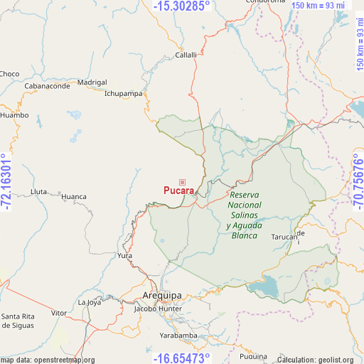
Pucara GPS coordinates[2]
15° 58' 47.748" South, 71° 27' 35.568" West
| Map corner | latitude | longitude |
|---|---|---|
| Upper-left | -15.30285°, | -72.16301° |
| Center: | -15.97993°, | -71.45988° |
| Lower-right: | -16.65473°, | -70.75676° |
| Map W x H: | 150.3×150.3 km | = 93.4×93.4mi |
| max Lat: | -0.96667° ⇑93.5% North |
| Pucara: | -15.97993° |
| min Lat: | ⇓6.5% South -18.01465° |
| min Long | Pucara | max Long |
| -81.30472° | -71.45988° | -69.04167° |
| W 85.8%⇐ | ⇒14.2% E |
Elevation
Elevation of Pucara is 4352 m = 14278 ft, and this is 2033.3 m = 6671 ft above average elevation for this country.
| Max E: |
5022 m = 16476 ft | 1.5% |
| Pucara | 4352 m 14278 ft | |
| Avg. | 2318.7 m = 7607 ft | |
Min E: |
1 m = 3 ft | 98.5% |
See also: Peru elevation on elevation.city.
Geographical zone
Pucara is located in South Torrid zone (between Equator and Tropic of Capricorn). Distance of this Southern Tropic circle is 829.1 km =515.2 mi to South.| Distance of | km | miles | from Pucara |
|---|---|---|---|
| Equator | 1776.8 | 1104.1 | to North |
| Tropic Capricorn | 829.1 | 515.2 | to South |
| Antarctic Circle | 5624.4 | 3494.8 | to South |
| South Pole | 8230.3 | 5114.1 | to South |


Nearby cities:
15 places around Pucara: (largest is in red/bold)
• Achoma
43.9 km =27.3 mi,  324°
324°
• Arequipa
47.3 km =29.4 mi,  189°
189°
• Chiguata
47.1 km =29.3 mi,  172°
172°
• Chivay
40.9 km =25.4 mi,  338°
338°
• Coporaque
44 km =27.3 mi,  333°
333°
• Huarancante
23.6 km =14.7 mi,  0°
0°
• Ichupampa
44.1 km =27.4 mi, 326°
• Jatun Orcochiri
28.3 km =17.6 mi,  25°
25°
• Jayune
49.3 km =30.6 mi,  19°
19°
• Llongasora
41.6 km =25.8 mi, 24°
• Maca
50.1 km =31.1 mi, 318°
• Tarucani
47.7 km =29.6 mi,  118°
118°
• Vizcachane
33.6 km =20.9 mi,  55°
55°
• Yanque
42.4 km =26.3 mi, 330°
• Yura
38.3 km =23.8 mi,  217°
217°
Sources, notices
• [Note1] Compared only with cities in Peru existing in our database
• [Src1] Map data: © OpenStreetMap contributors (CC-BY-SA)
• [Src2] Other city data from geonames.org with taken over terms of usage.
• [Src3] Geographical zone / Annual Mean Temperature by Robert A. Rohde @ Wikipedia
