Yura geodata
Yura (Arequipa) is a seat of a third-order administrative division; located in Peru in America/Lima (GMT-5) time zone. With population of 5,686 people, there are 219 cities with bigger population in this country. Compared to other cities in Peru, 94.7% of cities are located further ↑North; 83.7% of cities are located further ←West and 56.8% of cities have higher elevation than Yura. Note1


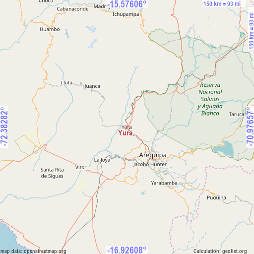
Yura GPS coordinates[2]
16° 15' 8.028" South, 71° 40' 46.884" West
| Map corner | latitude | longitude |
|---|---|---|
| Upper-left | -15.57606°, | -72.38282° |
| Center: | -16.25223°, | -71.67969° |
| Lower-right: | -16.92608°, | -70.97657° |
| Map W x H: | 150.1×150.1 km | = 93.3×93.3mi |
| max Lat: | -0.96667° ⇑94.7% North |
| Yura: | -16.25223° |
| min Lat: | ⇓5.3% South -18.01465° |
| min Long | Yura | max Long |
| -81.30472° | -71.67969° | -69.04167° |
| W 83.7%⇐ | ⇒16.3% E |
Elevation
Elevation of Yura is 2598 m = 8524 ft, and this is 279.3 m = 916 ft above average elevation for this country.
| Max E: |
5022 m = 16476 ft | 56.8% |
| Yura | 2598 m 8524 ft | |
| Avg. | 2318.7 m = 7607 ft | |
Min E: |
1 m = 3 ft | 43.2% |
See also: Peru elevation on elevation.city.
Geographical zone
Yura is located in South Torrid zone (between Equator and Tropic of Capricorn). Distance of this Southern Tropic circle is 798.8 km =496.4 mi to South.| Distance of | km | miles | from Yura |
|---|---|---|---|
| Equator | 1807.1 | 1122.9 | to North |
| Tropic Capricorn | 798.8 | 496.4 | to South |
| Antarctic Circle | 5594.1 | 3476 | to South |
| South Pole | 8200 | 5095.2 | to South |


Nearby cities:
15 places around Yura: (largest is in red/bold)
• Achoma
65.8 km =40.9 mi,  358°
358°
• Arequipa
22.5 km =14 mi,  136°
136°
• Characato
31.7 km =19.7 mi, 138°
• Chiguata
34.1 km =21.2 mi,  118°
118°
• Huarancante
58.8 km =36.5 mi,  23°
23°
• Lluta
44.4 km =27.6 mi,  306°
306°
• Pocsi
42.8 km =26.6 mi,  133°
133°
• Pucara
38.3 km =23.8 mi,  37°
37°
• Quequeña
41.8 km =26 mi, 144°
• Sabandia
30.6 km =19 mi, 141°
• Socabaya
29.2 km =18.1 mi,  146°
146°
• Tarucani
65.9 km =40.9 mi,  83°
83°
• Tiabaya
24 km =14.9 mi,  156°
156°
• Uchumayo
19.2 km =11.9 mi,  177°
177°
• Yarabamba
39.3 km =24.4 mi, 146°
Sources, notices
• [Note1] Compared only with cities in Peru existing in our database
• [Src1] Map data: © OpenStreetMap contributors (CC-BY-SA)
• [Src2] Other city data from geonames.org with taken over terms of usage.
• [Src3] Geographical zone / Annual Mean Temperature by Robert A. Rohde @ Wikipedia
