Tarucani geodata
Tarucani (Arequipa) is a seat of a third-order administrative division; located in Peru in America/Lima (GMT-5) time zone. In our database, there are 305 cities with bigger population. Compared to other cities in Peru, 94.2% of cities are located further ↑North; 89.8% of cities are located further ←West and 97.5% of cities have lower elevation than Tarucani. Note1
Administrative division(s):
- Level 1: Arequipa
- Level 2: Provincia de Arequipa
- Level 3: San Juan De Tarucani


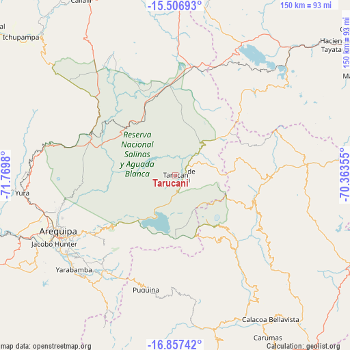
Tarucani GPS coordinates[2]
16° 10' 59.988" South, 71° 4' 0.012" West
| Map corner | latitude | longitude |
|---|---|---|
| Upper-left | -15.50693°, | -71.7698° |
| Center: | -16.18333°, | -71.06667° |
| Lower-right: | -16.85742°, | -70.36355° |
| Map W x H: | 150.2×150.2 km | = 93.3×93.3mi |
| max Lat: | -0.96667° ⇑94.2% North |
| Tarucani: | -16.18333° |
| min Lat: | ⇓5.8% South -18.01465° |
| min Long | Tarucani | max Long |
| -81.30472° | -71.06667° | -69.04167° |
| W 89.8%⇐ | ⇒10.2% E |
Elevation
Elevation of Tarucani is 4243 m = 13921 ft, and this is 1924.3 m = 6313 ft above average elevation for this country.
| Max E: |
5022 m = 16476 ft | 2.5% |
| Tarucani | 4243 m 13921 ft | |
| Avg. | 2318.7 m = 7607 ft | |
Min E: |
1 m = 3 ft | 97.5% |
See also: Peru elevation on elevation.city.
Geographical zone
Tarucani is located in South Torrid zone (between Equator and Tropic of Capricorn). Distance of this Southern Tropic circle is 806.5 km =501.1 mi to South.| Distance of | km | miles | from Tarucani |
|---|---|---|---|
| Equator | 1799.4 | 1118.1 | to North |
| Tropic Capricorn | 806.5 | 501.1 | to South |
| Antarctic Circle | 5601.8 | 3480.8 | to South |
| South Pole | 8207.6 | 5100 | to South |


Nearby cities:
15 places around Tarucani: (largest is in red/bold)
• Arequipa
55.4 km =34.4 mi,  244°
244°
• Characato
54.5 km =33.9 mi,  234°
234°
• Chiguata
43 km =26.7 mi, 235°
• Chojata
43 km =26.7 mi,  124°
124°
• Coalaque
52.2 km =32.4 mi,  174°
174°
• Hacienda Huancane
44.5 km =27.7 mi,  25°
25°
• Ichuña
53.5 km =33.2 mi,  86°
86°
• Lloque
39.3 km =24.4 mi, 115°
• Matalaque
42.7 km =26.5 mi,  141°
141°
• Pocsi
50.5 km =31.4 mi,  222°
222°
• Pucara
47.7 km =29.6 mi,  298°
298°
• Puquina
50.5 km =31.4 mi,  194°
194°
• Ubinas
32.2 km =20 mi, 138°
• Vizcachane
44.1 km =27.4 mi,  340°
340°
• Yunga
41 km =25.5 mi, 92°
Sources, notices
• [Note1] Compared only with cities in Peru existing in our database
• [Src1] Map data: © OpenStreetMap contributors (CC-BY-SA)
• [Src2] Other city data from geonames.org with taken over terms of usage.
• [Src3] Geographical zone / Annual Mean Temperature by Robert A. Rohde @ Wikipedia
