Tambo geodata
Tambo (Ayacucho) is a populated place; located in Peru in America/Lima (GMT-5) time zone. With population of 5,032 people, there are 235 cities with bigger population in this country. Compared to other cities in Peru, 84.3% of cities are located further ↑North; 66.6% of cities are located further ←West and 96.3% of cities have lower elevation than Tambo. Note1


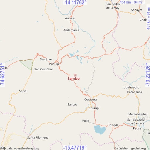
Tambo GPS coordinates[2]
14° 47' 54.492" South, 73° 55' 27.768" West
| Map corner | latitude | longitude |
|---|---|---|
| Upper-left | -14.11762°, | -74.62751° |
| Center: | -14.79847°, | -73.92438° |
| Lower-right: | -15.47719°, | -73.22126° |
| Map W x H: | 151.2×151.2 km | = 94×94mi |
| max Lat: | -0.96667° ⇑84.3% North |
| Tambo: | -14.79847° |
| min Lat: | ⇓15.7% South -18.01465° |
| min Long | Tambo | max Long |
| -81.30472° | -73.92438° | -69.04167° |
| W 66.6%⇐ | ⇒33.4% E |
Elevation
Elevation of Tambo is 4133 m = 13560 ft, and this is 1814.3 m = 5952 ft above average elevation for this country.
| Max E: |
5022 m = 16476 ft | 3.7% |
| Tambo | 4133 m 13560 ft | |
| Avg. | 2318.7 m = 7607 ft | |
Min E: |
1 m = 3 ft | 96.3% |
See also: Peru elevation on elevation.city.
Geographical zone
Tambo is located in South Torrid zone (between Equator and Tropic of Capricorn). Distance of this Southern Tropic circle is 960.5 km =596.8 mi to South.| Distance of | km | miles | from Tambo |
|---|---|---|---|
| Equator | 1645.4 | 1022.4 | to North |
| Tropic Capricorn | 960.5 | 596.8 | to South |
| Antarctic Circle | 5755.7 | 3576.4 | to South |
| South Pole | 8361.6 | 5195.7 | to South |


Nearby cities:
15 places around Tambo: (largest is in red/bold)
• Andamarca
45.9 km =28.5 mi,  355°
355°
• Aucara
57.8 km =35.9 mi,  354°
354°
• Cabana
56.6 km =35.2 mi, 355°
• Chaviña
22.8 km =14.2 mi,  154°
154°
• Chipao
48.3 km =30 mi,  6°
6°
• Chumpi
37.6 km =23.4 mi, 153°
• Coracora
30.2 km =18.8 mi, 149°
• Incuyo
62.1 km =38.6 mi,  143°
143°
• Lucanas
41.4 km =25.7 mi,  302°
302°
• Pacapausa
62.2 km =38.6 mi,  105°
105°
• Pullo
47.9 km =29.8 mi,  166°
166°
• Puquio
25 km =15.5 mi, 295°
• San Juan
33.9 km =21.1 mi, 299°
• San Pedro
19.2 km =11.9 mi,  280°
280°
• Upahuacho
57.4 km =35.7 mi,  101°
101°
Sources, notices
• [Note1] Compared only with cities in Peru existing in our database
• [Src1] Map data: © OpenStreetMap contributors (CC-BY-SA)
• [Src2] Other city data from geonames.org with taken over terms of usage.
• [Src3] Geographical zone / Annual Mean Temperature by Robert A. Rohde @ Wikipedia
