Coracora geodata
Coracora (Ayacucho) is a seat of a third-order administrative division; located in Peru in America/Lima (GMT-5) time zone. With population of 7,420 people, there are 180 cities with bigger population in this country. Compared to other cities in Peru, 85.5% of cities are located further ↑North; 68% of cities are located further ←West and 62.8% of cities have lower elevation than Coracora. Note1


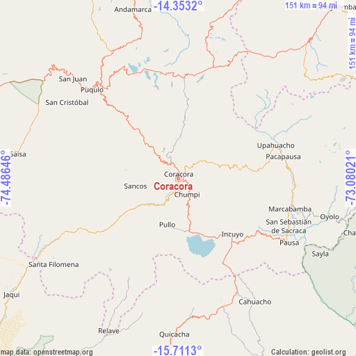
Coracora GPS coordinates[2]
15° 1' 59.988" South, 73° 46' 59.988" West
| Map corner | latitude | longitude |
|---|---|---|
| Upper-left | -14.3532°, | -74.48646° |
| Center: | -15.03333°, | -73.78333° |
| Lower-right: | -15.7113°, | -73.08021° |
| Map W x H: | 151×151 km | = 93.8×93.8mi |
| max Lat: | -0.96667° ⇑85.5% North |
| Coracora: | -15.03333° |
| min Lat: | ⇓14.5% South -18.01465° |
| min Long | Coracora | max Long |
| -81.30472° | -73.78333° | -69.04167° |
| W 68%⇐ | ⇒32% E |
Elevation
Elevation of Coracora is 3219 m = 10561 ft, and this is 900.3 m = 2954 ft above average elevation for this country.
| Max E: |
5022 m = 16476 ft | 37.2% |
| Coracora | 3219 m 10561 ft | |
| Avg. | 2318.7 m = 7607 ft | |
Min E: |
1 m = 3 ft | 62.8% |
See also: Peru elevation on elevation.city.
Geographical zone
Coracora is located in South Torrid zone (between Equator and Tropic of Capricorn). Distance of this Southern Tropic circle is 934.4 km =580.6 mi to South.| Distance of | km | miles | from Coracora |
|---|---|---|---|
| Equator | 1671.5 | 1038.6 | to North |
| Tropic Capricorn | 934.4 | 580.6 | to South |
| Antarctic Circle | 5729.6 | 3560.2 | to South |
| South Pole | 8335.5 | 5179.4 | to South |


Nearby cities:
15 places around Coracora: (largest is in red/bold)
• Aniso
58.5 km =36.4 mi,  64°
64°
• Chaviña
7.7 km =4.8 mi,  315°
315°
• Chumpi
7.6 km =4.7 mi,  166°
166°
• Colta
54.4 km =33.8 mi,  105°
105°
• Incuyo
32.3 km =20.1 mi,  138°
138°
• Lampa
49.6 km =30.8 mi, 109°
• Marcabamba
49.1 km =30.5 mi, 105°
• Pacapausa
45.6 km =28.3 mi,  78°
78°
• Pausa
54.4 km =33.8 mi,  120°
120°
• Pullo
20.7 km =12.9 mi,  189°
189°
• Puquio
52.8 km =32.8 mi,  314°
314°
• Quilcata
42.6 km =26.5 mi, 123°
• San Pedro
45.1 km =28 mi, 311°
• Tambo
30.2 km =18.8 mi,  329°
329°
• Upahuacho
43.6 km =27.1 mi,  70°
70°
Sources, notices
• [Note1] Compared only with cities in Peru existing in our database
• [Src1] Map data: © OpenStreetMap contributors (CC-BY-SA)
• [Src2] Other city data from geonames.org with taken over terms of usage.
• [Src3] Geographical zone / Annual Mean Temperature by Robert A. Rohde @ Wikipedia
