Suitucancha geodata
Suitucancha (Junin) is a seat of a third-order administrative division; located in Peru in America/Lima (GMT-5) time zone. In our database, there are 305 cities with bigger population. Compared to other cities in Peru, 50.2% of cities are located further ↑North; 52.6% of cities are located further →East and 97.7% of cities have lower elevation than Suitucancha. Note1


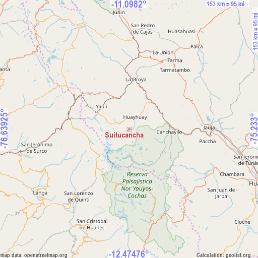
Suitucancha GPS coordinates[2]
11° 47' 14.424" South, 75° 56' 10.032" West
| Map corner | latitude | longitude |
|---|---|---|
| Upper-left | -11.0982°, | -76.63925° |
| Center: | -11.78734°, | -75.93612° |
| Lower-right: | -12.47476°, | -75.233° |
| Map W x H: | 153.1×153.1 km | = 95.1×95.1mi |
| max Lat: | -0.96667° ⇑50.2% North |
| Suitucancha: | -11.78734° |
| min Lat: | ⇓49.8% South -18.01465° |
| min Long | Suitucancha | max Long |
| -81.30472° | -75.93612° | -69.04167° |
| W 47.4%⇐ | ⇒52.6% E |
Elevation
Elevation of Suitucancha is 4254 m = 13957 ft, and this is 1935.3 m = 6349 ft above average elevation for this country.
| Max E: |
5022 m = 16476 ft | 2.3% |
| Suitucancha | 4254 m 13957 ft | |
| Avg. | 2318.7 m = 7607 ft | |
Min E: |
1 m = 3 ft | 97.7% |
See also: Peru elevation on elevation.city.
Geographical zone
Suitucancha is located in South Torrid zone (between Equator and Tropic of Capricorn). Distance of this Southern Tropic circle is 1295.3 km =804.9 mi to South.| Distance of | km | miles | from Suitucancha |
|---|---|---|---|
| Equator | 1310.6 | 814.4 | to North |
| Tropic Capricorn | 1295.3 | 804.9 | to South |
| Antarctic Circle | 6090.5 | 3784.5 | to South |
| South Pole | 8696.4 | 5403.7 | to South |


Nearby cities:
15 places around Suitucancha: (largest is in red/bold)
• Canchayllo
24 km =14.9 mi,  94°
94°
• Chacapalpa
20.5 km =12.7 mi,  72°
72°
• Chicla
37.3 km =23.2 mi,  283°
283°
• Concho
40.4 km =25.1 mi,  80°
80°
• El Rosario
28.5 km =17.7 mi, 89°
• La Oroya
30.1 km =18.7 mi,  7°
7°
• Llocllapampa
34.2 km =21.3 mi,  95°
95°
• Marco
41 km =25.5 mi, 82°
• Morococha
30.6 km =19 mi,  313°
313°
• Paccha
34.9 km =21.7 mi,  355°
355°
• Parco
42.5 km =26.4 mi, 91°
• Pomacancha
34.4 km =21.4 mi, 80°
• San Mateo
39.8 km =24.7 mi,  274°
274°
• Tanta
37.7 km =23.4 mi,  193°
193°
• Yauli
21.3 km =13.2 mi, 309°
Sources, notices
• [Note1] Compared only with cities in Peru existing in our database
• [Src1] Map data: © OpenStreetMap contributors (CC-BY-SA)
• [Src2] Other city data from geonames.org with taken over terms of usage.
• [Src3] Geographical zone / Annual Mean Temperature by Robert A. Rohde @ Wikipedia
