Chicla geodata
Chicla (Lima region) is a seat of a third-order administrative division; located in Peru in America/Lima (GMT-5) time zone. In our database, there are 305 cities with bigger population. Compared to other cities in Peru, 51.2% of cities are located further ↓South; 56.2% of cities are located further →East and 86.1% of cities have lower elevation than Chicla. Note1


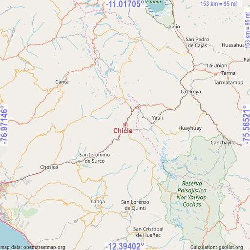
Chicla GPS coordinates[2]
11° 42' 23.004" South, 76° 16' 5.988" West
| Map corner | latitude | longitude |
|---|---|---|
| Upper-left | -11.01705°, | -76.97146° |
| Center: | -11.70639°, | -76.26833° |
| Lower-right: | -12.39402°, | -75.56521° |
| Map W x H: | 153.1×153.1 km | = 95.1×95.1mi |
| max Lat: | -0.96667° ⇑48.8% North |
| Chicla: | -11.70639° |
| min Lat: | ⇓51.2% South -18.01465° |
| min Long | Chicla | max Long |
| -81.30472° | -76.26833° | -69.04167° |
| W 43.8%⇐ | ⇒56.2% E |
Elevation
Elevation of Chicla is 3697 m = 12129 ft, and this is 1378.3 m = 4522 ft above average elevation for this country.
| Max E: |
5022 m = 16476 ft | 13.9% |
| Chicla | 3697 m 12129 ft | |
| Avg. | 2318.7 m = 7607 ft | |
Min E: |
1 m = 3 ft | 86.1% |
See also: Peru elevation on elevation.city.
Geographical zone
Chicla is located in South Torrid zone (between Equator and Tropic of Capricorn). Distance of Equator is 1301.6 km =808.8 mi to North.| Distance of | km | miles | from Chicla |
|---|---|---|---|
| Equator | 1301.6 | 808.8 | to North |
| Tropic Capricorn | 1304.3 | 810.5 | to South |
| Antarctic Circle | 6099.5 | 3790.1 | to South |
| South Pole | 8705.4 | 5409.3 | to South |


Nearby cities:
15 places around Chicla: (largest is in red/bold)
• Arahuay
44.7 km =27.8 mi,  282°
282°
• Callahuanca
40.2 km =25 mi,  250°
250°
• Carampoma
27.3 km =17 mi, 280°
• Cocachacra
37.3 km =23.2 mi,  231°
231°
• Huanza
26.2 km =16.3 mi, 282°
• Lachaqui
42.2 km =26.2 mi,  293°
293°
• Laraos
29.9 km =18.6 mi, 278°
• Marcapomacocha
34.1 km =21.2 mi,  347°
347°
• Matucana
21.5 km =13.4 mi,  221°
221°
• Morococha
18.2 km =11.3 mi,  49°
49°
• Paccha
42.4 km =26.3 mi, 52°
• San Mateo
6.9 km =4.3 mi,  210°
210°
• Suitucancha
37.3 km =23.2 mi,  103°
103°
• Surco
27.2 km =16.9 mi, 223°
• Yauli
20.3 km =12.6 mi,  76°
76°
Sources, notices
• [Note1] Compared only with cities in Peru existing in our database
• [Src1] Map data: © OpenStreetMap contributors (CC-BY-SA)
• [Src2] Other city data from geonames.org with taken over terms of usage.
• [Src3] Geographical zone / Annual Mean Temperature by Robert A. Rohde @ Wikipedia
