La Oroya geodata
La Oroya (Junin) is a seat of a third-order administrative division; located in Peru in America/Lima (GMT-5) time zone. With population of 33,345 people, there are 53 cities with bigger population in this country. Compared to other cities in Peru, 52.2% of cities are located further ↓South; 52.2% of cities are located further →East and 87.2% of cities have lower elevation than La Oroya. Note1


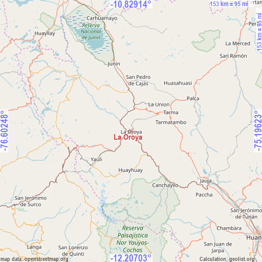
La Oroya GPS coordinates[2]
11° 31' 8.148" South, 75° 53' 57.66" West
| Map corner | latitude | longitude |
|---|---|---|
| Upper-left | -10.82914°, | -76.60248° |
| Center: | -11.51893°, | -75.89935° |
| Lower-right: | -12.20703°, | -75.19623° |
| Map W x H: | 153.2×153.2 km | = 95.2×95.2mi |
| max Lat: | -0.96667° ⇑47.8% North |
| La Oroya: | -11.51893° |
| min Lat: | ⇓52.2% South -18.01465° |
| min Long | La Oroya | max Long |
| -81.30472° | -75.89935° | -69.04167° |
| W 47.8%⇐ | ⇒52.2% E |
Elevation
Elevation of La Oroya is 3765 m = 12352 ft, and this is 1446.3 m = 4745 ft above average elevation for this country.
| Max E: |
5022 m = 16476 ft | 12.8% |
| La Oroya | 3765 m 12352 ft | |
| Avg. | 2318.7 m = 7607 ft | |
Min E: |
1 m = 3 ft | 87.2% |
See also: Peru elevation on elevation.city.
Geographical zone
La Oroya is located in South Torrid zone (between Equator and Tropic of Capricorn). Distance of Equator is 1280.8 km =795.9 mi to North.| Distance of | km | miles | from La Oroya |
|---|---|---|---|
| Equator | 1280.8 | 795.9 | to North |
| Tropic Capricorn | 1325.1 | 823.4 | to South |
| Antarctic Circle | 6120.4 | 3803 | to South |
| South Pole | 8726.3 | 5422.3 | to South |


Nearby cities:
15 places around La Oroya: (largest is in red/bold)
• Acobamba
31.8 km =19.8 mi,  54°
54°
• Canchayllo
37.6 km =23.4 mi,  148°
148°
• Chacapalpa
28.5 km =17.7 mi, 146°
• El Rosario
38.5 km =23.9 mi,  140°
140°
• Huasahuasi
39.4 km =24.5 mi,  44°
44°
• Leticia
22.2 km =13.8 mi, 45°
• Morococha
27.8 km =17.3 mi,  251°
251°
• Paccha
8.3 km =5.2 mi,  307°
307°
• Palcamayo
28.4 km =17.6 mi,  28°
28°
• Pomacancha
38.6 km =24 mi,  129°
129°
• San Pedro de Cajas
30.1 km =18.7 mi,  7°
7°
• Suitucancha
30.1 km =18.7 mi,  187°
187°
• Tapo
39.3 km =24.4 mi,  68°
68°
• Tarma
25.4 km =15.8 mi,  64°
64°
• Yauli
26.1 km =16.2 mi,  231°
231°
Sources, notices
• [Note1] Compared only with cities in Peru existing in our database
• [Src1] Map data: © OpenStreetMap contributors (CC-BY-SA)
• [Src2] Other city data from geonames.org with taken over terms of usage.
• [Src3] Geographical zone / Annual Mean Temperature by Robert A. Rohde @ Wikipedia
