Sangallaya geodata
Sangallaya (Lima region) is a seat of a third-order administrative division; located in Peru in America/Lima (GMT-5) time zone. In our database, there are 305 cities with bigger population. Compared to other cities in Peru, 55% of cities are located further ↑North; 56.1% of cities are located further →East and 94.6% of cities have lower elevation than Sangallaya. Note1
Administrative division(s):
- Level 1: Lima region
- Level 2: Provincia de Huarochirí
- Level 3: Sangallaya


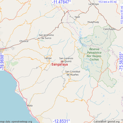
Sangallaya GPS coordinates[2]
12° 10' 0.012" South, 76° 16' 0.012" West
| Map corner | latitude | longitude |
|---|---|---|
| Upper-left | -11.47847°, | -76.9698° |
| Center: | -12.16667°, | -76.26667° |
| Lower-right: | -12.8531°, | -75.56355° |
| Map W x H: | 152.8×152.8 km | = 94.9×94.9mi |
| max Lat: | -0.96667° ⇑55% North |
| Sangallaya: | -12.16667° |
| min Lat: | ⇓45% South -18.01465° |
| min Long | Sangallaya | max Long |
| -81.30472° | -76.26667° | -69.04167° |
| W 43.9%⇐ | ⇒56.1% E |
Elevation
Elevation of Sangallaya is 4006 m = 13143 ft, and this is 1687.3 m = 5536 ft above average elevation for this country.
| Max E: |
5022 m = 16476 ft | 5.4% |
| Sangallaya | 4006 m 13143 ft | |
| Avg. | 2318.7 m = 7607 ft | |
Min E: |
1 m = 3 ft | 94.6% |
See also: Peru elevation on elevation.city.
Geographical zone
Sangallaya is located in South Torrid zone (between Equator and Tropic of Capricorn). Distance of this Southern Tropic circle is 1253.1 km =778.6 mi to South.| Distance of | km | miles | from Sangallaya |
|---|---|---|---|
| Equator | 1352.8 | 840.6 | to North |
| Tropic Capricorn | 1253.1 | 778.6 | to South |
| Antarctic Circle | 6048.4 | 3758.3 | to South |
| South Pole | 8654.3 | 5377.5 | to South |


Nearby cities:
15 places around Sangallaya: (largest is in red/bold)
• Calango
50 km =31.1 mi,  216°
216°
• Carania
47.6 km =29.6 mi,  114°
114°
• Cocachacra
40.8 km =25.4 mi,  313°
313°
• Huampara
22.3 km =13.9 mi,  156°
156°
• Lahuaytambo
16.3 km =10.1 mi,  297°
297°
• Mariatana
11.8 km =7.3 mi, 218°
• Matucana
38.1 km =23.7 mi,  337°
337°
• Miraflores
46.8 km =29.1 mi,  104°
104°
• Omas
39 km =24.2 mi,  182°
182°
• Quinocay
22.5 km =14 mi,  170°
170°
• San Mateo
45.4 km =28.2 mi,  355°
355°
• Surco
36.6 km =22.7 mi,  329°
329°
• Tanta
27.7 km =17.2 mi,  78°
78°
• Tauripampa
49.1 km =30.5 mi, 160°
• Yauyos
50 km =31.1 mi,  130°
130°
Sources, notices
• [Note1] Compared only with cities in Peru existing in our database
• [Src1] Map data: © OpenStreetMap contributors (CC-BY-SA)
• [Src2] Other city data from geonames.org with taken over terms of usage.
• [Src3] Geographical zone / Annual Mean Temperature by Robert A. Rohde @ Wikipedia
