Mariatana geodata
Mariatana (Lima region) is a seat of a third-order administrative division; located in Peru in America/Lima (GMT-5) time zone. In our database, there are 305 cities with bigger population. Compared to other cities in Peru, 55.7% of cities are located further ↑North; 57.2% of cities are located further →East and 80.9% of cities have lower elevation than Mariatana. Note1
Administrative division(s):
- Level 1: Lima region
- Level 2: Provincia de Huarochirí
- Level 3: Mariatana


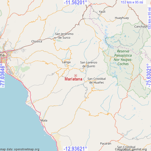
Mariatana GPS coordinates[2]
12° 15' 0" South, 76° 19' 59.988" West
| Map corner | latitude | longitude |
|---|---|---|
| Upper-left | -11.56201°, | -77.03646° |
| Center: | -12.25°, | -76.33333° |
| Lower-right: | -12.93621°, | -75.63021° |
| Map W x H: | 152.8×152.8 km | = 94.9×94.9mi |
| max Lat: | -0.96667° ⇑55.7% North |
| Mariatana: | -12.25° |
| min Lat: | ⇓44.3% South -18.01465° |
| min Long | Mariatana | max Long |
| -81.30472° | -76.33333° | -69.04167° |
| W 42.8%⇐ | ⇒57.2% E |
Elevation
Elevation of Mariatana is 3548 m = 11640 ft, and this is 1229.3 m = 4033 ft above average elevation for this country.
| Max E: |
5022 m = 16476 ft | 19.1% |
| Mariatana | 3548 m 11640 ft | |
| Avg. | 2318.7 m = 7607 ft | |
Min E: |
1 m = 3 ft | 80.9% |
See also: Peru elevation on elevation.city.
Geographical zone
Mariatana is located in South Torrid zone (between Equator and Tropic of Capricorn). Distance of this Southern Tropic circle is 1243.8 km =772.9 mi to South.| Distance of | km | miles | from Mariatana |
|---|---|---|---|
| Equator | 1362.1 | 846.4 | to North |
| Tropic Capricorn | 1243.8 | 772.9 | to South |
| Antarctic Circle | 6039.1 | 3752.5 | to South |
| South Pole | 8645 | 5371.8 | to South |


Nearby cities:
15 places around Mariatana: (largest is in red/bold)
• Calango
38.2 km =23.7 mi,  216°
216°
• Carania
51.6 km =32.1 mi,  101°
101°
• Cocachacra
43.6 km =27.1 mi,  329°
329°
• Huampara
19.7 km =12.2 mi,  124°
124°
• Lahuaytambo
18.2 km =11.3 mi,  336°
336°
• Matucana
45.1 km =28 mi,  350°
350°
• Omas
30.1 km =18.7 mi,  169°
169°
• Quinocay
16.9 km =10.5 mi,  140°
140°
• Ricardo Palma
50.8 km =31.6 mi,  316°
316°
• San Bartolo
51.1 km =31.8 mi,  253°
253°
• Sangallaya
11.8 km =7.3 mi,  38°
38°
• Surco
42.2 km =26.2 mi, 344°
• Tanta
37.5 km =23.3 mi,  66°
66°
• Tauripampa
43.9 km =27.3 mi,  147°
147°
• Yauyos
50.8 km =31.6 mi, 117°
Sources, notices
• [Note1] Compared only with cities in Peru existing in our database
• [Src1] Map data: © OpenStreetMap contributors (CC-BY-SA)
• [Src2] Other city data from geonames.org with taken over terms of usage.
• [Src3] Geographical zone / Annual Mean Temperature by Robert A. Rohde @ Wikipedia
