Cocachacra geodata
Cocachacra (Lima region) is a seat of a third-order administrative division; located in Peru in America/Lima (GMT-5) time zone. In our database, there are 305 cities with bigger population. Compared to other cities in Peru, 52.2% of cities are located further ↑North; 59.8% of cities are located further →East and 69.8% of cities have higher elevation than Cocachacra. Note1
Administrative division(s):
- Level 1: Lima region
- Level 2: Provincia de Huarochirí
- Level 3: Santa Cruz De Cocachacra


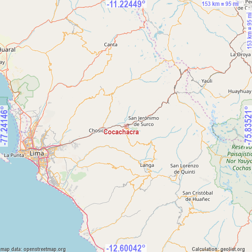
Cocachacra GPS coordinates[2]
11° 54' 47.988" South, 76° 32' 17.988" West
| Map corner | latitude | longitude |
|---|---|---|
| Upper-left | -11.22449°, | -77.24146° |
| Center: | -11.91333°, | -76.53833° |
| Lower-right: | -12.60042°, | -75.83521° |
| Map W x H: | 153×153 km | = 95.1×95.1mi |
| max Lat: | -0.96667° ⇑52.2% North |
| Cocachacra: | -11.91333° |
| min Lat: | ⇓47.8% South -18.01465° |
| min Long | Cocachacra | max Long |
| -81.30472° | -76.53833° | -69.04167° |
| W 40.2%⇐ | ⇒59.8% E |
Elevation
Elevation of Cocachacra is 1470 m = 4823 ft, and this is 848.7 m = 2784 ft below average elevation for this country.
| Max E: |
5022 m = 16476 ft | 69.8% |
| Avg. | 2318.7 m = 7607 ft | |
| Cocachacra | 1470 m = 4823 ft | |
Min E: |
1 m = 3 ft | 30.2% |
See also: Peru elevation on elevation.city.
Geographical zone
Cocachacra is located in South Torrid zone (between Equator and Tropic of Capricorn). Distance of this Southern Tropic circle is 1281.3 km =796.2 mi to South.| Distance of | km | miles | from Cocachacra |
|---|---|---|---|
| Equator | 1324.6 | 823.1 | to North |
| Tropic Capricorn | 1281.3 | 796.2 | to South |
| Antarctic Circle | 6076.5 | 3775.8 | to South |
| South Pole | 8682.4 | 5395 | to South |


Nearby cities:
15 places around Cocachacra: (largest is in red/bold)
• Arahuay
35.4 km =22 mi,  336°
336°
• Asentamiento Humano Nicolas de Pierola
18.4 km =11.4 mi,  262°
262°
• Callahuanca
12.7 km =7.9 mi,  318°
318°
• Carampoma
28.2 km =17.5 mi,  5°
5°
• Chaclacayo
26.1 km =16.2 mi,  252°
252°
• Chicla
37.3 km =23.2 mi,  51°
51°
• Chosica
18.9 km =11.7 mi, 259°
• Huanza
28.8 km =17.9 mi, 7°
• Lahuaytambo
25.6 km =15.9 mi,  144°
144°
• Laraos
27.6 km =17.1 mi,  359°
359°
• Matucana
16.6 km =10.3 mi,  64°
64°
• Ricardo Palma
12.8 km =8 mi,  266°
266°
• San Mateo
31 km =19.3 mi, 56°
• Santa Eulalia
13.7 km =8.5 mi,  275°
275°
• Surco
11.2 km =7 mi,  73°
73°
Sources, notices
• [Note1] Compared only with cities in Peru existing in our database
• [Src1] Map data: © OpenStreetMap contributors (CC-BY-SA)
• [Src2] Other city data from geonames.org with taken over terms of usage.
• [Src3] Geographical zone / Annual Mean Temperature by Robert A. Rohde @ Wikipedia
