Punta de Bombón geodata
Punta de Bombón (Arequipa) is a populated place; located in Peru in America/Lima (GMT-5) time zone. With population of 6,336 people, there are 199 cities with bigger population in this country. Compared to other cities in Peru, 97.6% of cities are located further ↑North; 82.5% of cities are located further ←West and 95.8% of cities have higher elevation than Punta de Bombón. Note1


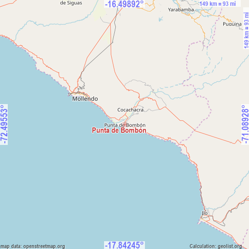
Punta de Bombón GPS coordinates[2]
17° 10' 18.84" South, 71° 47' 32.64" West
| Map corner | latitude | longitude |
|---|---|---|
| Upper-left | -16.49892°, | -72.49553° |
| Center: | -17.1719°, | -71.7924° |
| Lower-right: | -17.84245°, | -71.08928° |
| Map W x H: | 149.4×149.4 km | = 92.8×92.8mi |
| max Lat: | -0.96667° ⇑97.6% North |
| Punta de Bombón: | -17.1719° |
| min Lat: | ⇓2.4% South -18.01465° |
| min Long | Punta de Bombó | max Long |
| -81.30472° | -71.7924° | -69.04167° |
| W 82.5%⇐ | ⇒17.5% E |
Elevation
Elevation of Punta de Bombón is 25 m = 82 ft, and this is 2293.7 m = 7525 ft below average elevation for this country.
| Max E: |
5022 m = 16476 ft | 95.8% |
| Avg. | 2318.7 m = 7607 ft | |
| Punta de Bombón | 25 m = 82 ft | |
Min E: |
1 m = 3 ft | 4.2% |
See also: Peru elevation on elevation.city.
Geographical zone
Punta de Bombón is located in South Torrid zone (between Equator and Tropic of Capricorn). Distance of this Southern Tropic circle is 696.6 km =432.8 mi to South.| Distance of | km | miles | from Punta de Bombón |
|---|---|---|---|
| Equator | 1909.3 | 1186.4 | to North |
| Tropic Capricorn | 696.6 | 432.8 | to South |
| Antarctic Circle | 5491.8 | 3412.4 | to South |
| South Pole | 8097.7 | 5031.7 | to South |


Nearby cities:
15 places around Punta de Bombón: (largest is in red/bold)
• Cocachacra
10 km =6.2 mi,  21°
21°
• El Algarrobal
74.9 km =46.5 mi,  132°
132°
• Ilo
70.1 km =43.6 mi,  136°
136°
• La Capilla
79.9 km =49.6 mi,  54°
54°
• La Curva
4.2 km =2.6 mi,  312°
312°
• Mollendo
28.8 km =17.9 mi, 305°
• Pacocha
71 km =44.1 mi, 137°
• Pocsi
84.6 km =52.6 mi,  30°
30°
• Pueblo Nuevo
68.9 km =42.8 mi, 135°
• Quequeña
77.3 km =48 mi, 28°
• Sabandia
84.4 km =52.4 mi, 21°
• Socabaya
83 km =51.6 mi, 19°
• Tiabaya
83.1 km =51.6 mi, 15°
• Uchumayo
84 km =52.2 mi,  8°
8°
• Yarabamba
77.2 km =48 mi, 25°
Sources, notices
• [Note1] Compared only with cities in Peru existing in our database
• [Src1] Map data: © OpenStreetMap contributors (CC-BY-SA)
• [Src2] Other city data from geonames.org with taken over terms of usage.
• [Src3] Geographical zone / Annual Mean Temperature by Robert A. Rohde @ Wikipedia
