Ilo geodata
Ilo (Moquegua) is a seat of a third-order administrative division; located in Peru in America/Lima (GMT-5) time zone. With population of 53,476 people, there are 35 cities with bigger population in this country. Compared to other cities in Peru, 99.4% of cities are located further ↑North; 87.8% of cities are located further ←West and 89.6% of cities have higher elevation than Ilo. Note1


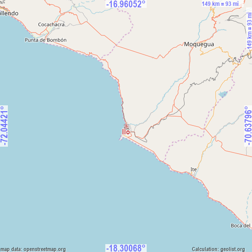
Ilo GPS coordinates[2]
17° 37' 54.66" South, 71° 20' 27.888" West
| Map corner | latitude | longitude |
|---|---|---|
| Upper-left | -16.96052°, | -72.04421° |
| Center: | -17.63185°, | -71.34108° |
| Lower-right: | -18.30068°, | -70.63796° |
| Map W x H: | 149×149 km | = 92.6×92.6mi |
| max Lat: | -0.96667° ⇑99.4% North |
| Ilo: | -17.63185° |
| min Lat: | ⇓0.6% South -18.01465° |
| min Long | Ilo | max Long |
| -81.30472° | -71.34108° | -69.04167° |
| W 87.8%⇐ | ⇒12.2% E |
Elevation
Elevation of Ilo is 95 m = 312 ft, and this is 2223.7 m = 7296 ft below average elevation for this country.
| Max E: |
5022 m = 16476 ft | 89.6% |
| Avg. | 2318.7 m = 7607 ft | |
| Ilo | 95 m = 312 ft | |
Min E: |
1 m = 3 ft | 10.4% |
See also: Ilo elevation on elevation.city.
Geographical zone
Ilo is located in South Torrid zone (between Equator and Tropic of Capricorn). Distance of this Southern Tropic circle is 645.4 km =401 mi to South.| Distance of | km | miles | from Ilo |
|---|---|---|---|
| Equator | 1960.5 | 1218.2 | to North |
| Tropic Capricorn | 645.4 | 401 | to South |
| Antarctic Circle | 5440.7 | 3380.7 | to South |
| South Pole | 8046.6 | 4999.9 | to South |


Nearby cities:
15 places around Ilo: (largest is in red/bold)
• Cocachacra
74.9 km =46.5 mi,  323°
323°
• El Algarrobal
7.8 km =4.8 mi,  82°
82°
• Ilabaya
90.8 km =56.4 mi, 75°
• La Capilla
98.8 km =61.4 mi,  10°
10°
• La Curva
74.2 km =46.1 mi, 316°
• Las Yaras
86.4 km =53.7 mi,  107°
107°
• Locumba
61.3 km =38.1 mi,  88°
88°
• Mollendo
98.5 km =61.2 mi,  313°
313°
• Moquegua
64.6 km =40.1 mi,  41°
41°
• Pacocha
1.6 km =1 mi,  194°
194°
• Pueblo Nuevo
1.9 km =1.2 mi, 8°
• Punta de Bombón
70.1 km =43.6 mi, 316°
• Sama Grande
91.4 km =56.8 mi,  101°
101°
• Samegua
68.8 km =42.8 mi, 43°
• Torata
81.2 km =50.5 mi, 40°
Sources, notices
• [Note1] Compared only with cities in Peru existing in our database
• [Src1] Map data: © OpenStreetMap contributors (CC-BY-SA)
• [Src2] Other city data from geonames.org with taken over terms of usage.
• [Src3] Geographical zone / Annual Mean Temperature by Robert A. Rohde @ Wikipedia
