La Curva geodata
La Curva (Arequipa) is a seat of a third-order administrative division; located in Peru in America/Lima (GMT-5) time zone. In our database, there are 305 cities with bigger population. Compared to other cities in Peru, 97.4% of cities are located further ↑North; 82.3% of cities are located further ←West and 97% of cities have higher elevation than La Curva. Note1


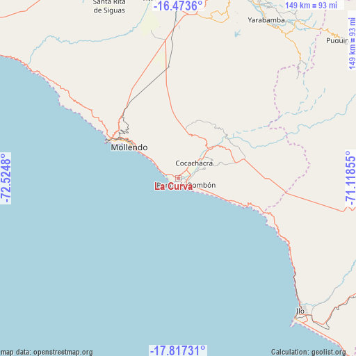
La Curva GPS coordinates[2]
17° 8' 48.012" South, 71° 49' 18.012" West
| Map corner | latitude | longitude |
|---|---|---|
| Upper-left | -16.4736°, | -72.5248° |
| Center: | -17.14667°, | -71.82167° |
| Lower-right: | -17.81731°, | -71.11855° |
| Map W x H: | 149.4×149.4 km | = 92.8×92.8mi |
| max Lat: | -0.96667° ⇑97.4% North |
| La Curva: | -17.14667° |
| min Lat: | ⇓2.6% South -18.01465° |
| min Long | La Curva | max Long |
| -81.30472° | -71.82167° | -69.04167° |
| W 82.3%⇐ | ⇒17.7% E |
Elevation
Elevation of La Curva is 17 m = 56 ft, and this is 2301.7 m = 7552 ft below average elevation for this country.
| Max E: |
5022 m = 16476 ft | 97% |
| Avg. | 2318.7 m = 7607 ft | |
| La Curva | 17 m = 56 ft | |
Min E: |
1 m = 3 ft | 3% |
See also: Peru elevation on elevation.city.
Geographical zone
La Curva is located in South Torrid zone (between Equator and Tropic of Capricorn). Distance of this Southern Tropic circle is 699.4 km =434.6 mi to South.| Distance of | km | miles | from La Curva |
|---|---|---|---|
| Equator | 1906.5 | 1184.6 | to North |
| Tropic Capricorn | 699.4 | 434.6 | to South |
| Antarctic Circle | 5494.6 | 3414.2 | to South |
| South Pole | 8100.5 | 5033.4 | to South |


Nearby cities:
15 places around La Curva: (largest is in red/bold)
• Cocachacra
9.4 km =5.8 mi,  46°
46°
• El Algarrobal
79.1 km =49.2 mi,  132°
132°
• Ilo
74.2 km =46.1 mi,  136°
136°
• La Capilla
80.9 km =50.3 mi,  57°
57°
• Mollendo
24.7 km =15.3 mi,  303°
303°
• Pacocha
75.1 km =46.7 mi, 137°
• Pueblo Nuevo
73.1 km =45.4 mi, 135°
• Punta de Bombón
4.2 km =2.6 mi, 132°
• Quequeña
76.4 km =47.5 mi,  31°
31°
• Quilca
81.1 km =50.4 mi,  306°
306°
• Sabandia
83 km =51.6 mi,  24°
24°
• Socabaya
81.5 km =50.6 mi, 22°
• Tiabaya
81.3 km =50.5 mi, 17°
• Uchumayo
81.8 km =50.8 mi,  11°
11°
• Yarabamba
76.1 km =47.3 mi, 28°
Sources, notices
• [Note1] Compared only with cities in Peru existing in our database
• [Src1] Map data: © OpenStreetMap contributors (CC-BY-SA)
• [Src2] Other city data from geonames.org with taken over terms of usage.
• [Src3] Geographical zone / Annual Mean Temperature by Robert A. Rohde @ Wikipedia
