Pomacanchi geodata
Pomacanchi (Cusco) is a seat of a third-order administrative division; located in Peru in America/Lima (GMT-5) time zone. In our database, there are 305 cities with bigger population. Compared to other cities in Peru, 74.4% of cities are located further ↑North; 84.6% of cities are located further ←West and 85.7% of cities have lower elevation than Pomacanchi. Note1


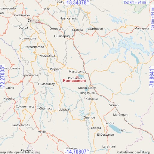
Pomacanchi GPS coordinates[2]
14° 1' 36.984" South, 71° 34' 1.992" West
| Map corner | latitude | longitude |
|---|---|---|
| Upper-left | -13.34378°, | -72.27035° |
| Center: | -14.02694°, | -71.56722° |
| Lower-right: | -14.70807°, | -70.8641° |
| Map W x H: | 151.7×151.7 km | = 94.3×94.3mi |
| max Lat: | -0.96667° ⇑74.4% North |
| Pomacanchi: | -14.02694° |
| min Lat: | ⇓25.6% South -18.01465° |
| min Long | Pomacanchi | max Long |
| -81.30472° | -71.56722° | -69.04167° |
| W 84.6%⇐ | ⇒15.4% E |
Elevation
Elevation of Pomacanchi is 3677 m = 12064 ft, and this is 1358.3 m = 4456 ft above average elevation for this country.
| Max E: |
5022 m = 16476 ft | 14.3% |
| Pomacanchi | 3677 m 12064 ft | |
| Avg. | 2318.7 m = 7607 ft | |
Min E: |
1 m = 3 ft | 85.7% |
See also: Peru elevation on elevation.city.
Geographical zone
Pomacanchi is located in South Torrid zone (between Equator and Tropic of Capricorn). Distance of this Southern Tropic circle is 1046.3 km =650.1 mi to South.| Distance of | km | miles | from Pomacanchi |
|---|---|---|---|
| Equator | 1559.6 | 969.1 | to North |
| Tropic Capricorn | 1046.3 | 650.1 | to South |
| Antarctic Circle | 5841.5 | 3629.7 | to South |
| South Pole | 8447.4 | 5249 | to South |


Nearby cities:
15 places around Pomacanchi: (largest is in red/bold)
• Acomayo
17.4 km =10.8 mi,  314°
314°
• Acos
20.2 km =12.6 mi,  294°
294°
• Ccuntuma
20 km =12.4 mi,  123°
123°
• Checacupe
12.3 km =7.6 mi,  90°
90°
• Combapata
17 km =10.6 mi, 119°
• Cusipata
15.2 km =9.4 mi,  29°
29°
• Mosoc Llacta
14.5 km =9 mi,  135°
135°
• Omacha
19.3 km =12 mi,  255°
255°
• Pampamarca
17.6 km =10.9 mi, 138°
• Pillpinto
22.3 km =13.9 mi, 291°
• Pitumarca
18 km =11.2 mi,  70°
70°
• Qquea
19.8 km =12.3 mi,  98°
98°
• Quiquijana
22.9 km =14.2 mi,  7°
7°
• Tinta
21.7 km =13.5 mi,  127°
127°
• Tungasuca
18.1 km =11.2 mi,  147°
147°
Sources, notices
• [Note1] Compared only with cities in Peru existing in our database
• [Src1] Map data: © OpenStreetMap contributors (CC-BY-SA)
• [Src2] Other city data from geonames.org with taken over terms of usage.
• [Src3] Geographical zone / Annual Mean Temperature by Robert A. Rohde @ Wikipedia
