Pilpichaca geodata
Pilpichaca (Huancavelica) is a seat of a third-order administrative division; located in Peru in America/Lima (GMT-5) time zone. In our database, there are 305 cities with bigger population. Compared to other cities in Peru, 64.3% of cities are located further ↑North; 58.8% of cities are located further ←West and 95.7% of cities have lower elevation than Pilpichaca. Note1


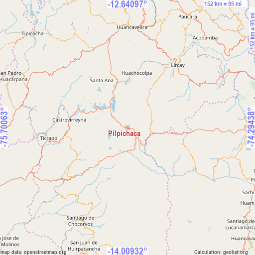
Pilpichaca GPS coordinates[2]
13° 19' 33.996" South, 74° 59' 51" West
| Map corner | latitude | longitude |
|---|---|---|
| Upper-left | -12.64097°, | -75.70063° |
| Center: | -13.32611°, | -74.9975° |
| Lower-right: | -14.00932°, | -74.29438° |
| Map W x H: | 152.1×152.1 km | = 94.5×94.5mi |
| max Lat: | -0.96667° ⇑64.3% North |
| Pilpichaca: | -13.32611° |
| min Lat: | ⇓35.7% South -18.01465° |
| min Long | Pilpichaca | max Long |
| -81.30472° | -74.9975° | -69.04167° |
| W 58.8%⇐ | ⇒41.2% E |
Elevation
Elevation of Pilpichaca is 4095 m = 13435 ft, and this is 1776.3 m = 5828 ft above average elevation for this country.
| Max E: |
5022 m = 16476 ft | 4.3% |
| Pilpichaca | 4095 m 13435 ft | |
| Avg. | 2318.7 m = 7607 ft | |
Min E: |
1 m = 3 ft | 95.7% |
See also: Peru elevation on elevation.city.
Geographical zone
Pilpichaca is located in South Torrid zone (between Equator and Tropic of Capricorn). Distance of this Southern Tropic circle is 1124.2 km =698.5 mi to South.| Distance of | km | miles | from Pilpichaca |
|---|---|---|---|
| Equator | 1481.7 | 920.7 | to North |
| Tropic Capricorn | 1124.2 | 698.5 | to South |
| Antarctic Circle | 5919.4 | 3678.1 | to South |
| South Pole | 8525.3 | 5297.4 | to South |


Nearby cities:
15 places around Pilpichaca: (largest is in red/bold)
• Anchonga
58.8 km =36.5 mi,  33°
33°
• Arma
62.5 km =38.8 mi,  291°
291°
• Castrovirreyna
35.2 km =21.9 mi,  280°
280°
• Cocas
40.5 km =25.2 mi, 279°
• Huachocolpa
33.6 km =20.9 mi,  9°
9°
• Huachos
57.9 km =36 mi, 284°
• Huancavelica
60.5 km =37.6 mi,  2°
2°
• Huayacundo Arma
40.7 km =25.3 mi,  234°
234°
• Lircay
47.3 km =29.4 mi,  39°
39°
• Mollepampa
43.6 km =27.1 mi,  273°
273°
• Quito-Arma
43 km =26.7 mi,  237°
237°
• Santa Ana
34 km =21.1 mi,  334°
334°
• Ticrapo
45.4 km =28.2 mi, 266°
• Totos
57.8 km =35.9 mi,  117°
117°
• Vilcanchos
59.5 km =37 mi, 122°
Sources, notices
• [Note1] Compared only with cities in Peru existing in our database
• [Src1] Map data: © OpenStreetMap contributors (CC-BY-SA)
• [Src2] Other city data from geonames.org with taken over terms of usage.
• [Src3] Geographical zone / Annual Mean Temperature by Robert A. Rohde @ Wikipedia
