Huarmey geodata
Huarmey (Ancash) is a seat of a third-order administrative division; located in Peru in America/Lima (GMT-5) time zone. With population of 16,172 people, there are 96 cities with bigger population in this country. Compared to other cities in Peru, 60.5% of cities are located further ↓South; 83% of cities are located further →East and 98.1% of cities have higher elevation than Huarmey. Note1


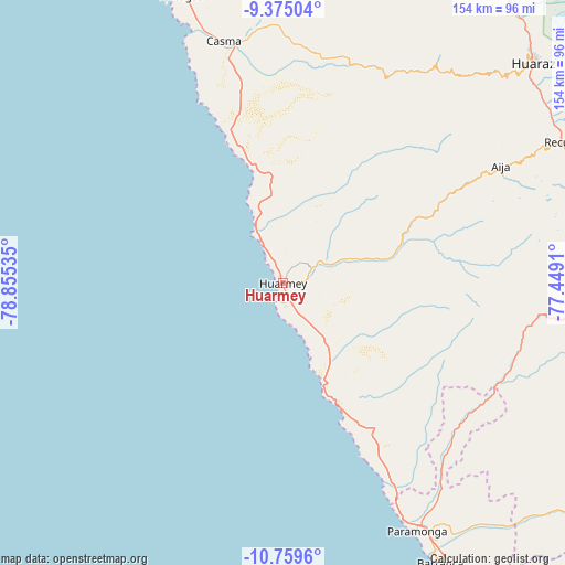
Huarmey GPS coordinates[2]
10° 4' 5.016" South, 78° 9' 7.992" West
| Map corner | latitude | longitude |
|---|---|---|
| Upper-left | -9.37504°, | -78.85535° |
| Center: | -10.06806°, | -78.15222° |
| Lower-right: | -10.7596°, | -77.4491° |
| Map W x H: | 153.9×154 km | = 95.6×95.7mi |
| max Lat: | -0.96667° ⇑39.5% North |
| Huarmey: | -10.06806° |
| min Lat: | ⇓60.5% South -18.01465° |
| min Long | Huarmey | max Long |
| -81.30472° | -78.15222° | -69.04167° |
| W 17%⇐ | ⇒83% E |
Elevation
Elevation of Huarmey is 13 m = 43 ft, and this is 2305.7 m = 7565 ft below average elevation for this country.
| Max E: |
5022 m = 16476 ft | 98.1% |
| Avg. | 2318.7 m = 7607 ft | |
| Huarmey | 13 m = 43 ft | |
Min E: |
1 m = 3 ft | 1.9% |
See also: Peru elevation on elevation.city.
Geographical zone
Huarmey is located in South Torrid zone (between Equator and Tropic of Capricorn). Distance of Equator is 1119.5 km =695.6 mi to North.| Distance of | km | miles | from Huarmey |
|---|---|---|---|
| Equator | 1119.5 | 695.6 | to North |
| Tropic Capricorn | 1486.5 | 923.7 | to South |
| Antarctic Circle | 6281.7 | 3903.3 | to South |
| South Pole | 8887.6 | 5522.5 | to South |


Nearby cities:
15 places around Huarmey: (largest is in red/bold)
• Aija
67.5 km =41.9 mi,  61°
61°
• Cajamarquilla
65.4 km =40.6 mi,  42°
42°
• Casma
68 km =42.3 mi,  346°
346°
• Chasquitambo
65.7 km =40.8 mi,  113°
113°
• Colcabamba
65.2 km =40.5 mi,  34°
34°
• Coris
51.2 km =31.8 mi, 59°
• Cotaparaco
60.9 km =37.8 mi,  82°
82°
• Huanchay
51 km =31.7 mi, 43°
• Huayllapampa
67.8 km =42.1 mi,  88°
88°
• La Caleta Culebras
15.5 km =9.6 mi,  328°
328°
• Llacllin
58.6 km =36.4 mi, 89°
• Malvas
54 km =33.6 mi,  71°
71°
• Pampas
56.7 km =35.2 mi, 38°
• Succha
60.9 km =37.8 mi, 64°
• Tapacocha
62.5 km =38.8 mi, 84°
Sources, notices
• [Note1] Compared only with cities in Peru existing in our database
• [Src1] Map data: © OpenStreetMap contributors (CC-BY-SA)
• [Src2] Other city data from geonames.org with taken over terms of usage.
• [Src3] Geographical zone / Annual Mean Temperature by Robert A. Rohde @ Wikipedia
