Huanchay geodata
Huanchay (Ancash) is a seat of a third-order administrative division; located in Peru in America/Lima (GMT-5) time zone. In our database, there are 305 cities with bigger population. Compared to other cities in Peru, 63.2% of cities are located further ↓South; 78.2% of cities are located further →East and 67.2% of cities have higher elevation than Huanchay. Note1


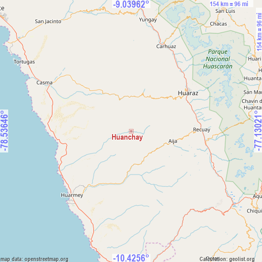
Huanchay GPS coordinates[2]
9° 43' 59.988" South, 77° 49' 59.988" West
| Map corner | latitude | longitude |
|---|---|---|
| Upper-left | -9.03962°, | -78.53646° |
| Center: | -9.73333°, | -77.83333° |
| Lower-right: | -10.4256°, | -77.13021° |
| Map W x H: | 154.1×154.1 km | = 95.8×95.8mi |
| max Lat: | -0.96667° ⇑36.8% North |
| Huanchay: | -9.73333° |
| min Lat: | ⇓63.2% South -18.01465° |
| min Long | Huanchay | max Long |
| -81.30472° | -77.83333° | -69.04167° |
| W 21.8%⇐ | ⇒78.2% E |
Elevation
Elevation of Huanchay is 1880 m = 6168 ft, and this is 438.7 m = 1439 ft below average elevation for this country.
| Max E: |
5022 m = 16476 ft | 67.2% |
| Avg. | 2318.7 m = 7607 ft | |
| Huanchay | 1880 m = 6168 ft | |
Min E: |
1 m = 3 ft | 32.8% |
See also: Peru elevation on elevation.city.
Geographical zone
Huanchay is located in South Torrid zone (between Equator and Tropic of Capricorn). Distance of Equator is 1082.2 km =672.4 mi to North.| Distance of | km | miles | from Huanchay |
|---|---|---|---|
| Equator | 1082.2 | 672.4 | to North |
| Tropic Capricorn | 1523.7 | 946.8 | to South |
| Antarctic Circle | 6318.9 | 3926.4 | to South |
| South Pole | 8924.8 | 5545.6 | to South |


Nearby cities:
15 places around Huanchay: (largest is in red/bold)
• Aija
25.1 km =15.6 mi,  102°
102°
• Cajamarquilla
14.4 km =8.9 mi,  39°
39°
• Cochabamba
26.8 km =16.7 mi,  353°
353°
• Colcabamba
16.8 km =10.4 mi,  6°
6°
• Coris
14.4 km =8.9 mi,  140°
140°
• Cotaparaco
39.1 km =24.3 mi, 139°
• Huaraz
40.5 km =25.2 mi,  55°
55°
• La Merced
23.7 km =14.7 mi,  90°
90°
• Malvas
26.2 km =16.3 mi, 141°
• Olleros
39.9 km =24.8 mi,  73°
73°
• Pampas
7.4 km =4.6 mi,  0°
0°
• Pira
22.5 km =14 mi,  34°
34°
• Recuay
41.3 km =25.7 mi, 88°
• Succha
23 km =14.3 mi,  118°
118°
• Tapacocha
41.7 km =25.9 mi, 139°
Sources, notices
• [Note1] Compared only with cities in Peru existing in our database
• [Src1] Map data: © OpenStreetMap contributors (CC-BY-SA)
• [Src2] Other city data from geonames.org with taken over terms of usage.
• [Src3] Geographical zone / Annual Mean Temperature by Robert A. Rohde @ Wikipedia
