Carampoma geodata
Carampoma (Lima region) is a seat of a third-order administrative division; located in Peru in America/Lima (GMT-5) time zone. In our database, there are 305 cities with bigger population. Compared to other cities in Peru, 51.5% of cities are located further ↓South; 59.4% of cities are located further →East and 69.5% of cities have lower elevation than Carampoma. Note1
Administrative division(s):
- Level 1: Lima region
- Level 2: Provincia de Huarochirí
- Level 3: Carampoma


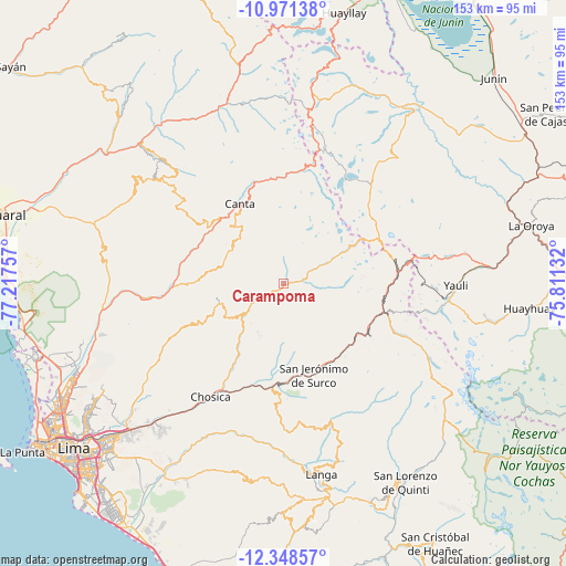
Carampoma GPS coordinates[2]
11° 39' 38.988" South, 76° 30' 51.984" West
| Map corner | latitude | longitude |
|---|---|---|
| Upper-left | -10.97138°, | -77.21757° |
| Center: | -11.66083°, | -76.51444° |
| Lower-right: | -12.34857°, | -75.81132° |
| Map W x H: | 153.1×153.1 km | = 95.1×95.1mi |
| max Lat: | -0.96667° ⇑48.5% North |
| Carampoma: | -11.66083° |
| min Lat: | ⇓51.5% South -18.01465° |
| min Long | Carampoma | max Long |
| -81.30472° | -76.51444° | -69.04167° |
| W 40.6%⇐ | ⇒59.4% E |
Elevation
Elevation of Carampoma is 3336 m = 10945 ft, and this is 1017.3 m = 3338 ft above average elevation for this country.
| Max E: |
5022 m = 16476 ft | 30.5% |
| Carampoma | 3336 m 10945 ft | |
| Avg. | 2318.7 m = 7607 ft | |
Min E: |
1 m = 3 ft | 69.5% |
See also: Peru elevation on elevation.city.
Geographical zone
Carampoma is located in South Torrid zone (between Equator and Tropic of Capricorn). Distance of Equator is 1296.6 km =805.7 mi to North.| Distance of | km | miles | from Carampoma |
|---|---|---|---|
| Equator | 1296.6 | 805.7 | to North |
| Tropic Capricorn | 1309.4 | 813.6 | to South |
| Antarctic Circle | 6104.6 | 3793.2 | to South |
| South Pole | 8710.5 | 5412.5 | to South |


Nearby cities:
15 places around Carampoma: (largest is in red/bold)
• Arahuay
17.4 km =10.8 mi,  284°
284°
• Callahuanca
21.7 km =13.5 mi,  210°
210°
• Canta
24.6 km =15.3 mi,  330°
330°
• Chicla
27.3 km =17 mi,  100°
100°
• Cocachacra
28.2 km =17.5 mi,  185°
185°
• Huamantanga
31.2 km =19.4 mi,  305°
305°
• Huanza
1.3 km =0.8 mi,  69°
69°
• Huaros
29.2 km =18.1 mi,  346°
346°
• Lachaqui
16.8 km =10.4 mi,  315°
315°
• Laraos
2.8 km =1.7 mi,  260°
260°
• Matucana
24.4 km =15.2 mi,  149°
149°
• San Buenaventura
25 km =15.5 mi, 319°
• San Mateo
25.7 km =16 mi,  115°
115°
• Santa Eulalia
31.2 km =19.4 mi, 211°
• Surco
26.2 km =16.3 mi,  161°
161°
Sources, notices
• [Note1] Compared only with cities in Peru existing in our database
• [Src1] Map data: © OpenStreetMap contributors (CC-BY-SA)
• [Src2] Other city data from geonames.org with taken over terms of usage.
• [Src3] Geographical zone / Annual Mean Temperature by Robert A. Rohde @ Wikipedia
