Huanza geodata
Huanza (Lima region) is a seat of a third-order administrative division; located in Peru in America/Lima (GMT-5) time zone. In our database, there are 305 cities with bigger population. Compared to other cities in Peru, 51.7% of cities are located further ↓South; 59.4% of cities are located further →East and 72.8% of cities have lower elevation than Huanza. Note1


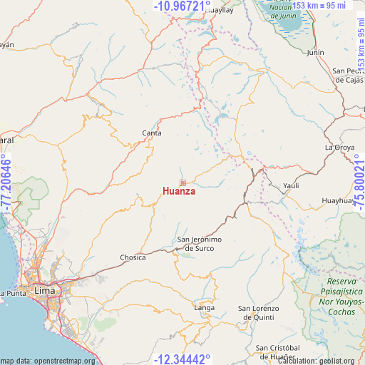
Huanza GPS coordinates[2]
11° 39' 24.012" South, 76° 30' 11.988" West
| Map corner | latitude | longitude |
|---|---|---|
| Upper-left | -10.96721°, | -77.20646° |
| Center: | -11.65667°, | -76.50333° |
| Lower-right: | -12.34442°, | -75.80021° |
| Map W x H: | 153.1×153.1 km | = 95.1×95.1mi |
| max Lat: | -0.96667° ⇑48.3% North |
| Huanza: | -11.65667° |
| min Lat: | ⇓51.7% South -18.01465° |
| min Long | Huanza | max Long |
| -81.30472° | -76.50333° | -69.04167° |
| W 40.6%⇐ | ⇒59.4% E |
Elevation
Elevation of Huanza is 3391 m = 11125 ft, and this is 1072.3 m = 3518 ft above average elevation for this country.
| Max E: |
5022 m = 16476 ft | 27.2% |
| Huanza | 3391 m 11125 ft | |
| Avg. | 2318.7 m = 7607 ft | |
Min E: |
1 m = 3 ft | 72.8% |
See also: Peru elevation on elevation.city.
Geographical zone
Huanza is located in South Torrid zone (between Equator and Tropic of Capricorn). Distance of Equator is 1296.1 km =805.4 mi to North.| Distance of | km | miles | from Huanza |
|---|---|---|---|
| Equator | 1296.1 | 805.4 | to North |
| Tropic Capricorn | 1309.8 | 813.9 | to South |
| Antarctic Circle | 6105.1 | 3793.5 | to South |
| South Pole | 8711 | 5412.8 | to South |


Nearby cities:
15 places around Huanza: (largest is in red/bold)
• Arahuay
18.5 km =11.5 mi,  281°
281°
• Callahuanca
22.7 km =14.1 mi,  212°
212°
• Canta
24.8 km =15.4 mi,  327°
327°
• Carampoma
1.3 km =0.8 mi,  249°
249°
• Chicla
26.2 km =16.3 mi,  102°
102°
• Cocachacra
28.8 km =17.9 mi,  187°
187°
• Huamantanga
32 km =19.9 mi,  303°
303°
• Huaros
29 km =18 mi,  343°
343°
• Lachaqui
17.4 km =10.8 mi,  311°
311°
• Laraos
4 km =2.5 mi,  257°
257°
• Matucana
24.3 km =15.1 mi,  152°
152°
• San Buenaventura
25.4 km =15.8 mi,  317°
317°
• San Mateo
24.9 km =15.5 mi,  117°
117°
• Santa Eulalia
32.3 km =20.1 mi, 212°
• Surco
26.3 km =16.3 mi,  164°
164°
Sources, notices
• [Note1] Compared only with cities in Peru existing in our database
• [Src1] Map data: © OpenStreetMap contributors (CC-BY-SA)
• [Src2] Other city data from geonames.org with taken over terms of usage.
• [Src3] Geographical zone / Annual Mean Temperature by Robert A. Rohde @ Wikipedia
