Cieneguilla geodata
Cieneguilla (Lima region) is a seat of a third-order administrative division; located in Peru in America/Lima (GMT-5) time zone. In our database, there are 305 cities with bigger population. Compared to other cities in Peru, 54.8% of cities are located further ↑North; 65.2% of cities are located further →East and 81.7% of cities have higher elevation than Cieneguilla. Note1


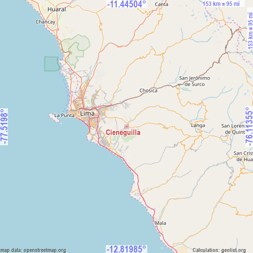
Cieneguilla GPS coordinates[2]
12° 7' 59.988" South, 76° 49' 0.012" West
| Map corner | latitude | longitude |
|---|---|---|
| Upper-left | -11.44504°, | -77.5198° |
| Center: | -12.13333°, | -76.81667° |
| Lower-right: | -12.81985°, | -76.11355° |
| Map W x H: | 152.9×152.9 km | = 95×95mi |
| max Lat: | -0.96667° ⇑54.8% North |
| Cieneguilla: | -12.13333° |
| min Lat: | ⇓45.2% South -18.01465° |
| min Long | Cieneguilla | max Long |
| -81.30472° | -76.81667° | -69.04167° |
| W 34.8%⇐ | ⇒65.2% E |
Elevation
Elevation of Cieneguilla is 272 m = 892 ft, and this is 2046.7 m = 6715 ft below average elevation for this country.
| Max E: |
5022 m = 16476 ft | 81.7% |
| Avg. | 2318.7 m = 7607 ft | |
| Cieneguilla | 272 m = 892 ft | |
Min E: |
1 m = 3 ft | 18.3% |
See also: Peru elevation on elevation.city.
Geographical zone
Cieneguilla is located in South Torrid zone (between Equator and Tropic of Capricorn). Distance of this Southern Tropic circle is 1256.8 km =780.9 mi to South.| Distance of | km | miles | from Cieneguilla |
|---|---|---|---|
| Equator | 1349.1 | 838.3 | to North |
| Tropic Capricorn | 1256.8 | 780.9 | to South |
| Antarctic Circle | 6052.1 | 3760.6 | to South |
| South Pole | 8658 | 5379.8 | to South |


Nearby cities:
15 places around Cieneguilla: (largest is in red/bold)
• Asentamiento Humano Nicolas de Pierola
25 km =15.5 mi,  28°
28°
• Chaclacayo
17.6 km =10.9 mi,  17°
17°
• Chosica
24.2 km =15 mi, 28°
• Independencia
29.6 km =18.4 mi,  302°
302°
• La Molina
15.5 km =9.6 mi,  290°
290°
• Lima
25.1 km =15.6 mi, 293°
• Punta Hermosa
22.2 km =13.8 mi,  180°
180°
• Ricardo Palma
29.5 km =18.3 mi,  36°
36°
• San Bartolo
28 km =17.4 mi,  172°
172°
• San Isidro
25.4 km =15.8 mi,  274°
274°
• San Luis
20.3 km =12.6 mi, 288°
• Santa Eulalia
30.8 km =19.1 mi, 32°
• Santa María
16.5 km =10.3 mi,  329°
329°
• Santiago de Surco
20.7 km =12.9 mi, 269°
• Vitarte
16.9 km =10.5 mi,  311°
311°
Sources, notices
• [Note1] Compared only with cities in Peru existing in our database
• [Src1] Map data: © OpenStreetMap contributors (CC-BY-SA)
• [Src2] Other city data from geonames.org with taken over terms of usage.
• [Src3] Geographical zone / Annual Mean Temperature by Robert A. Rohde @ Wikipedia
