Carhuamayo geodata
Carhuamayo (Junin) is a seat of a third-order administrative division; located in Peru in America/Lima (GMT-5) time zone. With population of 9,122 people, there are 153 cities with bigger population in this country. Compared to other cities in Peru, 56.1% of cities are located further ↓South; 53.3% of cities are located further →East and 97.8% of cities have lower elevation than Carhuamayo. Note1


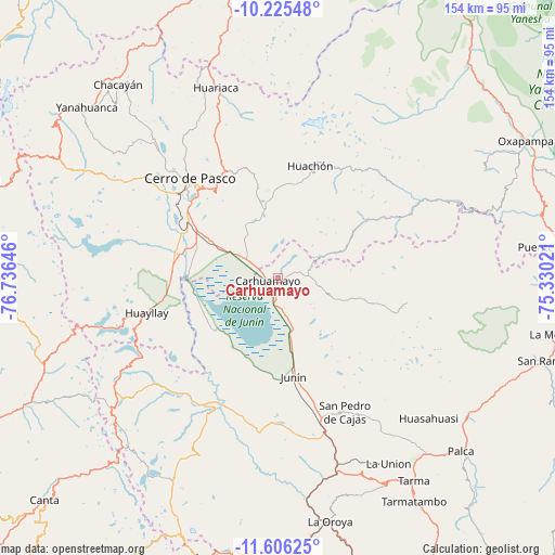
Carhuamayo GPS coordinates[2]
10° 55' 0.012" South, 76° 1' 59.988" West
| Map corner | latitude | longitude |
|---|---|---|
| Upper-left | -10.22548°, | -76.73646° |
| Center: | -10.91667°, | -76.03333° |
| Lower-right: | -11.60625°, | -75.33021° |
| Map W x H: | 153.5×153.5 km | = 95.4×95.4mi |
| max Lat: | -0.96667° ⇑43.9% North |
| Carhuamayo: | -10.91667° |
| min Lat: | ⇓56.1% South -18.01465° |
| min Long | Carhuamayo | max Long |
| -81.30472° | -76.03333° | -69.04167° |
| W 46.7%⇐ | ⇒53.3% E |
Elevation
Elevation of Carhuamayo is 4263 m = 13986 ft, and this is 1944.3 m = 6379 ft above average elevation for this country.
| Max E: |
5022 m = 16476 ft | 2.2% |
| Carhuamayo | 4263 m 13986 ft | |
| Avg. | 2318.7 m = 7607 ft | |
Min E: |
1 m = 3 ft | 97.8% |
See also: Peru elevation on elevation.city.
Geographical zone
Carhuamayo is located in South Torrid zone (between Equator and Tropic of Capricorn). Distance of Equator is 1213.8 km =754.2 mi to North.| Distance of | km | miles | from Carhuamayo |
|---|---|---|---|
| Equator | 1213.8 | 754.2 | to North |
| Tropic Capricorn | 1392.1 | 865 | to South |
| Antarctic Circle | 6187.4 | 3844.7 | to South |
| South Pole | 8793.2 | 5463.8 | to South |


Nearby cities:
15 places around Carhuamayo: (largest is in red/bold)
• Acobamba
63.2 km =39.3 mi,  140°
140°
• Cerro de Pasco
36.9 km =22.9 mi,  318°
318°
• Huariaca
55.5 km =34.5 mi,  342°
342°
• Huasahuasi
57.2 km =35.5 mi,  132°
132°
• Huayllay
37.4 km =23.2 mi,  255°
255°
• Junín
27.3 km =17 mi,  170°
170°
• Leticia
59.8 km =37.2 mi,  149°
149°
• Ninacaca
11.7 km =7.3 mi,  309°
309°
• Ondores
22.7 km =14.1 mi,  213°
213°
• Paccha
62.5 km =38.8 mi, 172°
• Palcamayo
50.7 km =31.5 mi, 146°
• Pallanchacra
60 km =37.3 mi, 338°
• Paucartambo
29 km =18 mi,  56°
56°
• San Pedro de Cajas
41.6 km =25.8 mi, 153°
• Tinyahuarco
31.2 km =19.4 mi,  302°
302°
Sources, notices
• [Note1] Compared only with cities in Peru existing in our database
• [Src1] Map data: © OpenStreetMap contributors (CC-BY-SA)
• [Src2] Other city data from geonames.org with taken over terms of usage.
• [Src3] Geographical zone / Annual Mean Temperature by Robert A. Rohde @ Wikipedia
