Palcamayo geodata
Palcamayo (Junin) is a seat of a third-order administrative division; located in Peru in America/Lima (GMT-5) time zone. In our database, there are 305 cities with bigger population. Compared to other cities in Peru, 53.6% of cities are located further ↓South; 50.7% of cities are located further →East and 69.7% of cities have lower elevation than Palcamayo. Note1


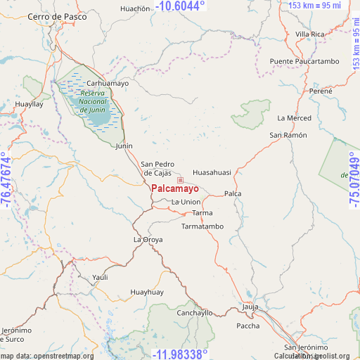
Palcamayo GPS coordinates[2]
11° 17' 40.992" South, 75° 46' 24.996" West
| Map corner | latitude | longitude |
|---|---|---|
| Upper-left | -10.6044°, | -76.47674° |
| Center: | -11.29472°, | -75.77361° |
| Lower-right: | -11.98338°, | -75.07049° |
| Map W x H: | 153.3×153.3 km | = 95.3×95.3mi |
| max Lat: | -0.96667° ⇑46.4% North |
| Palcamayo: | -11.29472° |
| min Lat: | ⇓53.6% South -18.01465° |
| min Long | Palcamayo | max Long |
| -81.30472° | -75.77361° | -69.04167° |
| W 49.3%⇐ | ⇒50.7% E |
Elevation
Elevation of Palcamayo is 3338 m = 10951 ft, and this is 1019.3 m = 3344 ft above average elevation for this country.
| Max E: |
5022 m = 16476 ft | 30.3% |
| Palcamayo | 3338 m 10951 ft | |
| Avg. | 2318.7 m = 7607 ft | |
Min E: |
1 m = 3 ft | 69.7% |
See also: Peru elevation on elevation.city.
Geographical zone
Palcamayo is located in South Torrid zone (between Equator and Tropic of Capricorn). Distance of Equator is 1255.9 km =780.4 mi to North.| Distance of | km | miles | from Palcamayo |
|---|---|---|---|
| Equator | 1255.9 | 780.4 | to North |
| Tropic Capricorn | 1350.1 | 838.9 | to South |
| Antarctic Circle | 6145.3 | 3818.5 | to South |
| South Pole | 8751.2 | 5437.7 | to South |


Nearby cities:
15 places around Palcamayo: (largest is in red/bold)
• Acobamba
13.8 km =8.6 mi,  117°
117°
• Carhuamayo
50.7 km =31.5 mi,  326°
326°
• Chacapalpa
48.8 km =30.3 mi,  177°
177°
• Huasahuasi
14.2 km =8.8 mi,  76°
76°
• Junín
28.3 km =17.6 mi,  302°
302°
• La Oroya
28.4 km =17.6 mi,  208°
208°
• Leticia
9.7 km =6 mi,  167°
167°
• Ondores
47 km =29.2 mi, 299°
• Paccha
28.5 km =17.7 mi,  225°
225°
• Palca
23.1 km =14.4 mi,  104°
104°
• Pomacancha
51.9 km =32.2 mi,  161°
161°
• San Pedro de Cajas
10.7 km =6.6 mi, 297°
• San Ramón
49.2 km =30.6 mi,  67°
67°
• Tapo
25.3 km =15.7 mi,  114°
114°
• Tarma
16.6 km =10.3 mi,  146°
146°
Sources, notices
• [Note1] Compared only with cities in Peru existing in our database
• [Src1] Map data: © OpenStreetMap contributors (CC-BY-SA)
• [Src2] Other city data from geonames.org with taken over terms of usage.
• [Src3] Geographical zone / Annual Mean Temperature by Robert A. Rohde @ Wikipedia
