Junín geodata
Junín (Junin) is a populated place; located in Peru in America/Lima (GMT-5) time zone. With population of 15,320 people, there are 104 cities with bigger population in this country. Compared to other cities in Peru, 54.5% of cities are located further ↓South; 52.7% of cities are located further →East and 96.1% of cities have lower elevation than Junín. Note1


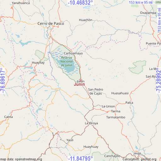
Junín GPS coordinates[2]
11° 9' 32.22" South, 75° 59' 34.944" West
| Map corner | latitude | longitude |
|---|---|---|
| Upper-left | -10.46832°, | -76.69617° |
| Center: | -11.15895°, | -75.99304° |
| Lower-right: | -11.84795°, | -75.28992° |
| Map W x H: | 153.4×153.4 km | = 95.3×95.3mi |
| max Lat: | -0.96667° ⇑45.5% North |
| Junín: | -11.15895° |
| min Lat: | ⇓54.5% South -18.01465° |
| min Long | Junín | max Long |
| -81.30472° | -75.99304° | -69.04167° |
| W 47.3%⇐ | ⇒52.7% E |
Elevation
Elevation of Junín is 4117 m = 13507 ft, and this is 1798.3 m = 5900 ft above average elevation for this country.
| Max E: |
5022 m = 16476 ft | 3.9% |
| Junín | 4117 m 13507 ft | |
| Avg. | 2318.7 m = 7607 ft | |
Min E: |
1 m = 3 ft | 96.1% |
See also: Peru elevation on elevation.city.
Geographical zone
Junín is located in South Torrid zone (between Equator and Tropic of Capricorn). Distance of Equator is 1240.8 km =771 mi to North.| Distance of | km | miles | from Junín |
|---|---|---|---|
| Equator | 1240.8 | 771 | to North |
| Tropic Capricorn | 1365.2 | 848.3 | to South |
| Antarctic Circle | 6160.4 | 3827.9 | to South |
| South Pole | 8766.3 | 5447.1 | to South |


Nearby cities:
15 places around Junín: (largest is in red/bold)
• Acobamba
42 km =26.1 mi,  120°
120°
• Carhuamayo
27.3 km =17 mi,  350°
350°
• Huasahuasi
39.5 km =24.5 mi,  107°
107°
• Huayllay
44.1 km =27.4 mi,  293°
293°
• La Oroya
41.3 km =25.7 mi,  165°
165°
• Leticia
35.8 km =22.2 mi,  133°
133°
• Marcapomacocha
46.5 km =28.9 mi,  233°
233°
• Ninacaca
36.9 km =22.9 mi,  338°
338°
• Ondores
18.8 km =11.7 mi,  295°
295°
• Paccha
35.2 km =21.9 mi, 174°
• Palca
50.7 km =31.5 mi, 114°
• Palcamayo
28.3 km =17.6 mi, 122°
• Paucartambo
47.3 km =29.4 mi,  24°
24°
• San Pedro de Cajas
17.6 km =10.9 mi, 125°
• Tarma
43.9 km =27.3 mi, 131°
Sources, notices
• [Note1] Compared only with cities in Peru existing in our database
• [Src1] Map data: © OpenStreetMap contributors (CC-BY-SA)
• [Src2] Other city data from geonames.org with taken over terms of usage.
• [Src3] Geographical zone / Annual Mean Temperature by Robert A. Rohde @ Wikipedia
