Leticia geodata
Leticia (Junin) is a seat of a third-order administrative division; located in Peru in America/Lima (GMT-5) time zone. In our database, there are 305 cities with bigger population. Compared to other cities in Peru, 53.3% of cities are located further ↓South; 50.3% of cities are located further →East and 80.8% of cities have lower elevation than Leticia. Note1


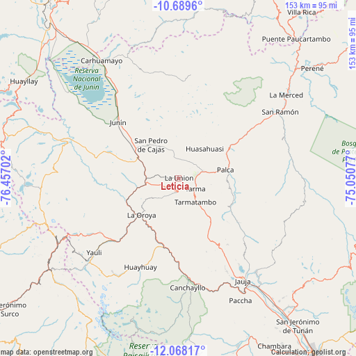
Leticia GPS coordinates[2]
11° 22' 46.992" South, 75° 45' 14.004" West
| Map corner | latitude | longitude |
|---|---|---|
| Upper-left | -10.6896°, | -76.45702° |
| Center: | -11.37972°, | -75.75389° |
| Lower-right: | -12.06817°, | -75.05077° |
| Map W x H: | 153.3×153.3 km | = 95.3×95.3mi |
| max Lat: | -0.96667° ⇑46.7% North |
| Leticia: | -11.37972° |
| min Lat: | ⇓53.3% South -18.01465° |
| min Long | Leticia | max Long |
| -81.30472° | -75.75389° | -69.04167° |
| W 49.7%⇐ | ⇒50.3% E |
Elevation
Elevation of Leticia is 3547 m = 11637 ft, and this is 1228.3 m = 4030 ft above average elevation for this country.
| Max E: |
5022 m = 16476 ft | 19.2% |
| Leticia | 3547 m 11637 ft | |
| Avg. | 2318.7 m = 7607 ft | |
Min E: |
1 m = 3 ft | 80.8% |
See also: Peru elevation on elevation.city.
Geographical zone
Leticia is located in South Torrid zone (between Equator and Tropic of Capricorn). Distance of Equator is 1265.3 km =786.2 mi to North.| Distance of | km | miles | from Leticia |
|---|---|---|---|
| Equator | 1265.3 | 786.2 | to North |
| Tropic Capricorn | 1340.6 | 833 | to South |
| Antarctic Circle | 6135.9 | 3812.7 | to South |
| South Pole | 8741.8 | 5431.9 | to South |


Nearby cities:
15 places around Leticia: (largest is in red/bold)
• Acobamba
10.5 km =6.5 mi,  73°
73°
• Acolla
45.2 km =28.1 mi,  150°
150°
• Chacapalpa
39.3 km =24.4 mi,  180°
180°
• Concho
43.3 km =26.9 mi, 152°
• Huasahuasi
17.2 km =10.7 mi,  42°
42°
• Junín
35.8 km =22.2 mi,  313°
313°
• La Oroya
22.2 km =13.8 mi,  225°
225°
• Marco
45.3 km =28.1 mi, 152°
• Paccha
24.8 km =15.4 mi,  245°
245°
• Palca
20.5 km =12.7 mi,  79°
79°
• Palcamayo
9.7 km =6 mi,  347°
347°
• Pomacancha
42.3 km =26.3 mi,  160°
160°
• San Pedro de Cajas
18.5 km =11.5 mi,  320°
320°
• Tapo
20.8 km =12.9 mi,  93°
93°
• Tarma
8.2 km =5.1 mi,  122°
122°
Sources, notices
• [Note1] Compared only with cities in Peru existing in our database
• [Src1] Map data: © OpenStreetMap contributors (CC-BY-SA)
• [Src2] Other city data from geonames.org with taken over terms of usage.
• [Src3] Geographical zone / Annual Mean Temperature by Robert A. Rohde @ Wikipedia
