San Pedro de Cajas geodata
San Pedro de Cajas (Junin) is a populated place; located in Peru in America/Lima (GMT-5) time zone. With population of 5,758 people, there are 217 cities with bigger population in this country. Compared to other cities in Peru, 54% of cities are located further ↓South; 51.9% of cities are located further →East and 94.7% of cities have lower elevation than San Pedro de Cajas. Note1


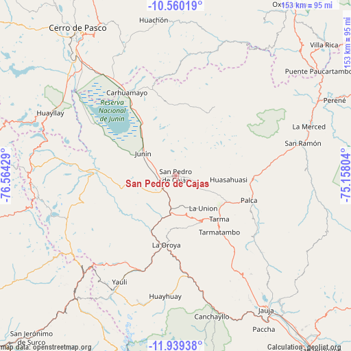
San Pedro de Cajas GPS coordinates[2]
11° 15' 2.196" South, 75° 51' 40.176" West
| Map corner | latitude | longitude |
|---|---|---|
| Upper-left | -10.56019°, | -76.56429° |
| Center: | -11.25061°, | -75.86116° |
| Lower-right: | -11.93938°, | -75.15804° |
| Map W x H: | 153.4×153.4 km | = 95.3×95.3mi |
| max Lat: | -0.96667° ⇑46% North |
| San Pedro de Cajas: | -11.25061° |
| min Lat: | ⇓54% South -18.01465° |
| min Long | San Pedro de Ca | max Long |
| -81.30472° | -75.86116° | -69.04167° |
| W 48.1%⇐ | ⇒51.9% E |
Elevation
Elevation of San Pedro de Cajas is 4022 m = 13196 ft, and this is 1703.3 m = 5588 ft above average elevation for this country.
| Max E: |
5022 m = 16476 ft | 5.3% |
| San Pedro de Cajas | 4022 m 13196 ft | |
| Avg. | 2318.7 m = 7607 ft | |
Min E: |
1 m = 3 ft | 94.7% |
See also: Peru elevation on elevation.city.
Geographical zone
San Pedro de Cajas is located in South Torrid zone (between Equator and Tropic of Capricorn). Distance of Equator is 1251 km =777.3 mi to North.| Distance of | km | miles | from San Pedro de Cajas |
|---|---|---|---|
| Equator | 1251 | 777.3 | to North |
| Tropic Capricorn | 1355 | 842 | to South |
| Antarctic Circle | 6150.2 | 3821.6 | to South |
| South Pole | 8756.1 | 5440.8 | to South |


Nearby cities:
15 places around San Pedro de Cajas: (largest is in red/bold)
• Acobamba
24.5 km =15.2 mi,  117°
117°
• Carhuamayo
41.6 km =25.8 mi,  333°
333°
• Huasahuasi
23.4 km =14.5 mi,  93°
93°
• Junín
17.6 km =10.9 mi,  305°
305°
• La Oroya
30.1 km =18.7 mi,  187°
187°
• Leticia
18.5 km =11.5 mi,  140°
140°
• Morococha
49.4 km =30.7 mi,  218°
218°
• Ninacaca
52.6 km =32.7 mi, 327°
• Ondores
36.3 km =22.6 mi,  300°
300°
• Paccha
27.1 km =16.8 mi,  203°
203°
• Palca
33.6 km =20.9 mi,  108°
108°
• Palcamayo
10.7 km =6.6 mi, 117°
• Tapo
36 km =22.4 mi, 115°
• Tarma
26.4 km =16.4 mi, 135°
• Yauli
52.2 km =32.4 mi,  208°
208°
Sources, notices
• [Note1] Compared only with cities in Peru existing in our database
• [Src1] Map data: © OpenStreetMap contributors (CC-BY-SA)
• [Src2] Other city data from geonames.org with taken over terms of usage.
• [Src3] Geographical zone / Annual Mean Temperature by Robert A. Rohde @ Wikipedia
