Ayo geodata
Ayo (Arequipa) is a seat of a third-order administrative division; located in Peru in America/Lima (GMT-5) time zone. In our database, there are 305 cities with bigger population. Compared to other cities in Peru, 91.6% of cities are located further ↑North; 78.5% of cities are located further ←West and 65.3% of cities have higher elevation than Ayo. Note1


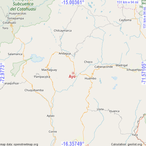
Ayo GPS coordinates[2]
15° 40' 54.012" South, 72° 16' 27.012" West
| Map corner | latitude | longitude |
|---|---|---|
| Upper-left | -15.00361°, | -72.9773° |
| Center: | -15.68167°, | -72.27417° |
| Lower-right: | -16.35749°, | -71.57105° |
| Map W x H: | 150.5×150.5 km | = 93.5×93.5mi |
| max Lat: | -0.96667° ⇑91.6% North |
| Ayo: | -15.68167° |
| min Lat: | ⇓8.4% South -18.01465° |
| min Long | Ayo | max Long |
| -81.30472° | -72.27417° | -69.04167° |
| W 78.5%⇐ | ⇒21.5% E |
Elevation
Elevation of Ayo is 1983 m = 6506 ft, and this is 335.7 m = 1101 ft below average elevation for this country.
| Max E: |
5022 m = 16476 ft | 65.3% |
| Avg. | 2318.7 m = 7607 ft | |
| Ayo | 1983 m = 6506 ft | |
Min E: |
1 m = 3 ft | 34.7% |
See also: Peru elevation on elevation.city.
Geographical zone
Ayo is located in South Torrid zone (between Equator and Tropic of Capricorn). Distance of this Southern Tropic circle is 862.3 km =535.8 mi to South.| Distance of | km | miles | from Ayo |
|---|---|---|---|
| Equator | 1743.6 | 1083.4 | to North |
| Tropic Capricorn | 862.3 | 535.8 | to South |
| Antarctic Circle | 5657.5 | 3515.4 | to South |
| South Pole | 8263.4 | 5134.6 | to South |


Nearby cities:
15 places around Ayo: (largest is in red/bold)
• Aplao
49.7 km =30.9 mi,  208°
208°
• Cabanaconde
32.3 km =20.1 mi,  78°
78°
• Choco
19.4 km =12.1 mi,  52°
52°
• Chuquibamba
44.2 km =27.5 mi,  246°
246°
• Huambo
18.7 km =11.6 mi,  107°
107°
• Huancarqui
50.7 km =31.5 mi,  204°
204°
• Iray
42.3 km =26.3 mi,  242°
242°
• Lluta
46.3 km =28.8 mi,  143°
143°
• Maca
54.2 km =33.7 mi,  85°
85°
• Madrigal
50.6 km =31.4 mi, 80°
• Orcopampa
46.8 km =29.1 mi,  351°
351°
• Pampacolca
32.3 km =20.1 mi,  263°
263°
• Tapay
37.7 km =23.4 mi,  72°
72°
• Uñon
17.5 km =10.9 mi, 252°
• Viraco
27 km =16.8 mi,  275°
275°
Sources, notices
• [Note1] Compared only with cities in Peru existing in our database
• [Src1] Map data: © OpenStreetMap contributors (CC-BY-SA)
• [Src2] Other city data from geonames.org with taken over terms of usage.
• [Src3] Geographical zone / Annual Mean Temperature by Robert A. Rohde @ Wikipedia
