Alca geodata
Alca (Arequipa) is a seat of a third-order administrative division; located in Peru in America/Lima (GMT-5) time zone. In our database, there are 305 cities with bigger population. Compared to other cities in Peru, 86.1% of cities are located further ↑North; 75.3% of cities are located further ←West and 53.7% of cities have higher elevation than Alca. Note1


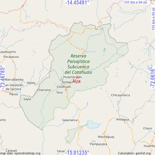
Alca GPS coordinates[2]
15° 8' 4.992" South, 72° 45' 52.992" West
| Map corner | latitude | longitude |
|---|---|---|
| Upper-left | -14.45491°, | -73.46785° |
| Center: | -15.13472°, | -72.76472° |
| Lower-right: | -15.81235°, | -72.0616° |
| Map W x H: | 150.9×150.9 km | = 93.8×93.8mi |
| max Lat: | -0.96667° ⇑86.1% North |
| Alca: | -15.13472° |
| min Lat: | ⇓13.9% South -18.01465° |
| min Long | Alca | max Long |
| -81.30472° | -72.76472° | -69.04167° |
| W 75.3%⇐ | ⇒24.7% E |
Elevation
Elevation of Alca is 2731 m = 8960 ft, and this is 412.3 m = 1353 ft above average elevation for this country.
| Max E: |
5022 m = 16476 ft | 53.7% |
| Alca | 2731 m 8960 ft | |
| Avg. | 2318.7 m = 7607 ft | |
Min E: |
1 m = 3 ft | 46.3% |
See also: Peru elevation on elevation.city.
Geographical zone
Alca is located in South Torrid zone (between Equator and Tropic of Capricorn). Distance of this Southern Tropic circle is 923.1 km =573.6 mi to South.| Distance of | km | miles | from Alca |
|---|---|---|---|
| Equator | 1682.8 | 1045.6 | to North |
| Tropic Capricorn | 923.1 | 573.6 | to South |
| Antarctic Circle | 5718.4 | 3553.2 | to South |
| South Pole | 8324.2 | 5172.4 | to South |


Nearby cities:
15 places around Alca: (largest is in red/bold)
• Charcana
34.9 km =21.7 mi,  250°
250°
• Chichas
48.8 km =30.3 mi,  199°
199°
• Colta
57 km =35.4 mi,  266°
266°
• Corculla
48.9 km =30.4 mi, 253°
• Cotahuasi
15.9 km =9.9 mi,  236°
236°
• Marcabamba
62 km =38.5 mi, 268°
• Mungui
16 km =9.9 mi, 250°
• Orcopampa
47.7 km =29.6 mi,  107°
107°
• Oyolo
45.5 km =28.3 mi,  263°
263°
• Puyca
11.5 km =7.1 mi,  43°
43°
• Tauria
55.9 km =34.7 mi, 243°
• Taurisma
10.2 km =6.3 mi, 243°
• Tomepampa
8.3 km =5.2 mi, 239°
• Toro
22.7 km =14.1 mi,  230°
230°
• Velinga
31.6 km =19.6 mi, 240°
Sources, notices
• [Note1] Compared only with cities in Peru existing in our database
• [Src1] Map data: © OpenStreetMap contributors (CC-BY-SA)
• [Src2] Other city data from geonames.org with taken over terms of usage.
• [Src3] Geographical zone / Annual Mean Temperature by Robert A. Rohde @ Wikipedia
