Duraznopampa geodata
Duraznopampa (Amazonas) is a seat of a third-order administrative division; located in Peru in America/Lima (GMT-5) time zone. In our database, there are 305 cities with bigger population. Compared to other cities in Peru, 83.6% of cities are located further ↓South; 77.6% of cities are located further →East and 63.2% of cities have higher elevation than Duraznopampa. Note1
Administrative division(s):
- Level 1: Amazonas
- Level 2: Provincia de Chachapoyas
- Level 3: Mariscal Castilla


Duraznopampa GPS coordinates[2]
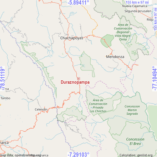
6° 35' 35.016" South, 77° 48' 29.016" West
| Map corner | latitude | longitude |
|---|---|---|
| Upper-left | -5.89411°, | -78.51119° |
| Center: | -6.59306°, | -77.80806° |
| Lower-right: | -7.29103°, | -77.10494° |
| Map W x H: | 155.3×155.3 km | = 96.5×96.5mi |
| max Lat: | -0.96667° ⇑16.4% North |
| Duraznopampa: | -6.59306° |
| min Lat: | ⇓83.6% South -18.01465° |
| min Long | Duraznopampa | max Long |
| -81.30472° | -77.80806° | -69.04167° |
| W 22.4%⇐ | ⇒77.6% E |
Elevation
Elevation of Duraznopampa is 2212 m = 7257 ft, and this is 106.7 m = 350 ft below average elevation for this country.
| Max E: |
5022 m = 16476 ft | 63.2% |
| Avg. | 2318.7 m = 7607 ft | |
| Duraznopampa | 2212 m = 7257 ft | |
Min E: |
1 m = 3 ft | 36.8% |
See also: Peru elevation on elevation.city.
Geographical zone
Duraznopampa is located in South Torrid zone (between Equator and Tropic of Capricorn). Distance of Equator is 733.1 km =455.5 mi to North.| Distance of | km | miles | from Duraznopampa |
|---|---|---|---|
| Equator | 733.1 | 455.5 | to North |
| Tropic Capricorn | 1872.8 | 1163.7 | to South |
| Antarctic Circle | 6668.1 | 4143.4 | to South |
| South Pole | 9274 | 5762.6 | to South |


Nearby cities:
15 places around Duraznopampa: (largest is in red/bold)
• Balsas
35.3 km =21.9 mi,  220°
220°
• Chuquibamba
38.2 km =23.7 mi,  187°
187°
• Cocabamba
23.1 km =14.4 mi,  268°
268°
• Cochamal
32.4 km =20.1 mi,  50°
50°
• Colcamar
37.2 km =23.1 mi,  330°
330°
• Huambo
35.2 km =21.9 mi,  58°
58°
• La Jalca
11.9 km =7.4 mi,  356°
356°
• Levanto
33.2 km =20.6 mi,  342°
342°
• Longar
37.3 km =23.2 mi, 51°
• Longuita
26.7 km =16.6 mi,  318°
318°
• Magdalena
26.5 km =16.5 mi, 337°
• Maino
29.6 km =18.4 mi, 344°
• Montevideo
2.6 km =1.6 mi,  166°
166°
• Soloco
37.5 km =23.3 mi,  10°
10°
• Tingo
27.2 km =16.9 mi, 335°
Sources, notices
• [Note1] Compared only with cities in Peru existing in our database
• [Src1] Map data: © OpenStreetMap contributors (CC-BY-SA)
• [Src2] Other city data from geonames.org with taken over terms of usage.
• [Src3] Geographical zone / Annual Mean Temperature by Robert A. Rohde @ Wikipedia
