Cochabamba geodata
Cochabamba (Huanuco) is a seat of a third-order administrative division; located in Peru in America/Lima (GMT-5) time zone. In our database, there are 305 cities with bigger population. Compared to other cities in Peru, 68.3% of cities are located further ↓South; 65.6% of cities are located further →East and 66.2% of cities have lower elevation than Cochabamba. Note1


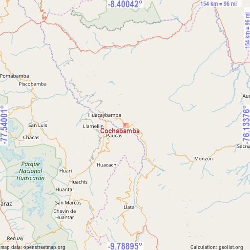
Cochabamba GPS coordinates[2]
9° 5' 43.296" South, 76° 50' 12.768" West
| Map corner | latitude | longitude |
|---|---|---|
| Upper-left | -8.40042°, | -77.54001° |
| Center: | -9.09536°, | -76.83688° |
| Lower-right: | -9.78895°, | -76.13376° |
| Map W x H: | 154.4×154.4 km | = 95.9×95.9mi |
| max Lat: | -0.96667° ⇑31.7% North |
| Cochabamba: | -9.09536° |
| min Lat: | ⇓68.3% South -18.01465° |
| min Long | Cochabamba | max Long |
| -81.30472° | -76.83688° | -69.04167° |
| W 34.4%⇐ | ⇒65.6% E |
Elevation
Elevation of Cochabamba is 3278 m = 10755 ft, and this is 959.3 m = 3147 ft above average elevation for this country.
| Max E: |
5022 m = 16476 ft | 33.8% |
| Cochabamba | 3278 m 10755 ft | |
| Avg. | 2318.7 m = 7607 ft | |
Min E: |
1 m = 3 ft | 66.2% |
See also: Peru elevation on elevation.city.
Geographical zone
Cochabamba is located in South Torrid zone (between Equator and Tropic of Capricorn). Distance of Equator is 1011.3 km =628.4 mi to North.| Distance of | km | miles | from Cochabamba |
|---|---|---|---|
| Equator | 1011.3 | 628.4 | to North |
| Tropic Capricorn | 1594.6 | 990.8 | to South |
| Antarctic Circle | 6389.9 | 3970.5 | to South |
| South Pole | 8995.8 | 5589.7 | to South |


Nearby cities:
15 places around Cochabamba: (largest is in red/bold)
• Aczo
17.9 km =11.1 mi,  249°
249°
• Anra
18 km =11.2 mi,  211°
211°
• Arancay
12.9 km =8 mi,  131°
131°
• Chingas
17.2 km =10.7 mi,  260°
260°
• Huacachi
27.1 km =16.8 mi,  204°
204°
• Huacaybamba
14.2 km =8.8 mi,  296°
296°
• Huacchis
12.9 km =8 mi,  155°
155°
• Llata
36.2 km =22.5 mi,  170°
170°
• Miraflores
44.4 km =27.6 mi,  177°
177°
• Paucas
9.3 km =5.8 mi,  227°
227°
• Punchao
40.8 km =25.4 mi, 177°
• Rapayan
14.6 km =9.1 mi,  144°
144°
• Singa
32.6 km =20.3 mi, 175°
• Tantamayo
35.2 km =21.9 mi, 159°
• Uco
14.4 km =8.9 mi,  223°
223°
Sources, notices
• [Note1] Compared only with cities in Peru existing in our database
• [Src1] Map data: © OpenStreetMap contributors (CC-BY-SA)
• [Src2] Other city data from geonames.org with taken over terms of usage.
• [Src3] Geographical zone / Annual Mean Temperature by Robert A. Rohde @ Wikipedia
