Pajarillo geodata
Pajarillo (San Martín) is a seat of a third-order administrative division; located in Peru in America/Lima (GMT-5) time zone. In our database, there are 305 cities with bigger population. Compared to other cities in Peru, 77.9% of cities are located further ↓South; 62.2% of cities are located further →East and 81.9% of cities have higher elevation than Pajarillo. Note1
Administrative division(s):
- Level 1: San Martín
- Level 2: Provincia de Mariscal Cáceres
- Level 3: Pajarillo


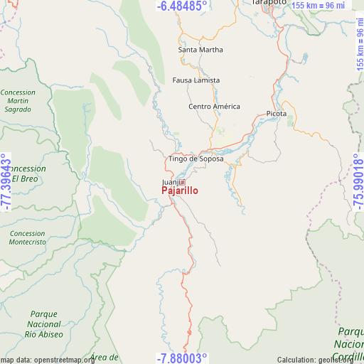
Pajarillo GPS coordinates[2]
7° 10' 58.728" South, 76° 41' 35.88" West
| Map corner | latitude | longitude |
|---|---|---|
| Upper-left | -6.48485°, | -77.39643° |
| Center: | -7.18298°, | -76.6933° |
| Lower-right: | -7.88003°, | -75.99018° |
| Map W x H: | 155.1×155.1 km | = 96.4×96.4mi |
| max Lat: | -0.96667° ⇑22.1% North |
| Pajarillo: | -7.18298° |
| min Lat: | ⇓77.9% South -18.01465° |
| min Long | Pajarillo | max Long |
| -81.30472° | -76.6933° | -69.04167° |
| W 37.8%⇐ | ⇒62.2% E |
Elevation
Elevation of Pajarillo is 270 m = 886 ft, and this is 2048.7 m = 6721 ft below average elevation for this country.
| Max E: |
5022 m = 16476 ft | 81.9% |
| Avg. | 2318.7 m = 7607 ft | |
| Pajarillo | 270 m = 886 ft | |
Min E: |
1 m = 3 ft | 18.1% |
See also: Peru elevation on elevation.city.
Geographical zone
Pajarillo is located in South Torrid zone (between Equator and Tropic of Capricorn). Distance of Equator is 798.7 km =496.3 mi to North.| Distance of | km | miles | from Pajarillo |
|---|---|---|---|
| Equator | 798.7 | 496.3 | to North |
| Tropic Capricorn | 1807.2 | 1122.9 | to South |
| Antarctic Circle | 6602.5 | 4102.6 | to South |
| South Pole | 9208.4 | 5721.8 | to South |


Nearby cities:
15 places around Pajarillo: (largest is in red/bold)
• Agua Blanca
51.1 km =31.8 mi,  359°
359°
• Bellavista
18.1 km =11.2 mi,  38°
38°
• Caspisapa
39.4 km =24.5 mi,  50°
50°
• Huicungo
17.6 km =10.9 mi,  211°
211°
• Juanjuí
3.9 km =2.4 mi,  279°
279°
• Ledoy
7.7 km =4.8 mi, 38°
• Picota
49.5 km =30.8 mi, 53°
• Piscoyacu
24 km =14.9 mi,  339°
339°
• Pucacaca
53.5 km =33.2 mi, 46°
• Puerto Rico
36.9 km =22.9 mi, 54°
• Sacanche
12.9 km =8 mi,  349°
349°
• San Pablo
42.5 km =26.4 mi,  17°
17°
• San Rafael
29.5 km =18.3 mi, 54°
• Santa Rosa
56.2 km =34.9 mi,  8°
8°
• Saposoa
29 km =18 mi, 342°
Sources, notices
• [Note1] Compared only with cities in Peru existing in our database
• [Src1] Map data: © OpenStreetMap contributors (CC-BY-SA)
• [Src2] Other city data from geonames.org with taken over terms of usage.
• [Src3] Geographical zone / Annual Mean Temperature by Robert A. Rohde @ Wikipedia
