Haapu geodata
Haapu (Leeward Islands) is a populated place; located in French Polynesia in Pacific/Tahiti (GMT-10) time zone. With population of 579 people, there are 38 cities with bigger population in this country. Compared to other cities in French Polynesia, 76.9% of cities are located further ↓South; 76.9% of cities are located further →East and 74.4% of cities have lower elevation than Haapu. Note1


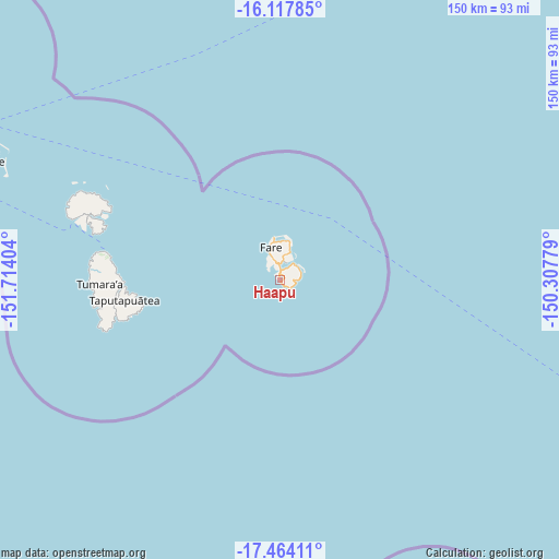
Haapu GPS coordinates[2]
16° 47' 31.812" South, 151° 0' 39.276" West
| Map corner | latitude | longitude |
|---|---|---|
| Upper-left | -16.11785°, | -151.71404° |
| Center: | -16.79217°, | -151.01091° |
| Lower-right: | -17.46411°, | -150.30779° |
| Map W x H: | 149.7×149.7 km | = 93×93mi |
| max Lat: | -8.91093° ⇑23.1% North |
| Haapu: | -16.79217° |
| min Lat: | ⇓76.9% South -23.34722° |
| min Long | Haapu | max Long |
| -151.74913° | -151.01091° | -134.96858° |
| W 23.1%⇐ | ⇒76.9% E |
Elevation
Elevation of Haapu is 17 m = 56 ft, and this is 5.6 m = 18 ft below average elevation for this country.
| Max E: |
245 m = 804 ft | 25.6% |
| Avg. | 22.6 m = 74 ft | |
| Haapu | 17 m = 56 ft | |
Min E: |
1 m = 3 ft | 74.4% |
See also: French Polynesia elevation on elevation.city.
Geographical zone
Haapu is located in South Torrid zone (between Equator and Tropic of Capricorn). Distance of this Southern Tropic circle is 738.8 km =459.1 mi to South.| Distance of | km | miles | from Haapu |
|---|---|---|---|
| Equator | 1867.1 | 1160.2 | to North |
| Tropic Capricorn | 738.8 | 459.1 | to South |
| Antarctic Circle | 5534.1 | 3438.7 | to South |
| South Pole | 8139.9 | 5057.9 | to South |


Nearby cities:
15 places around Haapu: (largest is in red/bold)
• Afareaitu
155.3 km =96.5 mi,  122°
122°
• Anau
82.3 km =51.1 mi,  293°
293°
• Faaa
171.9 km =106.8 mi, 119°
• Faanui
84.9 km =52.8 mi, 293°
• Fare
9.4 km =5.8 mi,  344°
344°
• Fitii
6.7 km =4.2 mi, 339°
• Haapiti
148.6 km =92.3 mi,  125°
125°
• Paopao
149.9 km =93.1 mi, 122°
• Papeete
174.4 km =108.4 mi, 118°
• Papetoai
143.9 km =89.4 mi, 122°
• Pirae
176.4 km =109.6 mi, 117°
• Teavaro
153.9 km =95.6 mi, 120°
• Tevaitoa
50.9 km =31.6 mi,  270°
270°
• Uturoa
46.7 km =29 mi,  278°
278°
• Vaitape
84.8 km =52.7 mi, 291°
Sources, notices
• [Note1] Compared only with cities in French Polynesia existing in our database
• [Src1] Map data: © OpenStreetMap contributors (CC-BY-SA)
• [Src2] Other city data from geonames.org with taken over terms of usage.
• [Src3] Geographical zone / Annual Mean Temperature by Robert A. Rohde @ Wikipedia
