Fare geodata
Fare (Leeward Islands) is a populated place; located in French Polynesia in Pacific/Tahiti (GMT-10) time zone. With population of 1,540 people, there are 28 cities with bigger population in this country. Compared to other cities in French Polynesia, 87.2% of cities are located further ↓South; 82.1% of cities are located further →East and 79.5% of cities have higher elevation than Fare. Note1


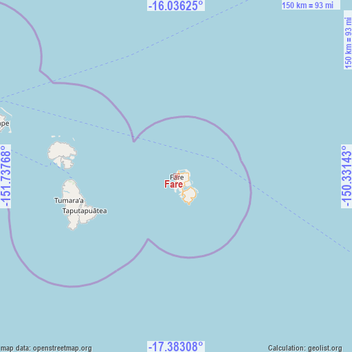
Fare GPS coordinates[2]
16° 42' 39.06" South, 151° 2' 4.38" West
| Map corner | latitude | longitude |
|---|---|---|
| Upper-left | -16.03625°, | -151.73768° |
| Center: | -16.71085°, | -151.03455° |
| Lower-right: | -17.38308°, | -150.33143° |
| Map W x H: | 149.8×149.8 km | = 93.1×93.1mi |
| max Lat: | -8.91093° ⇑12.8% North |
| Fare: | -16.71085° |
| min Lat: | ⇓87.2% South -23.34722° |
| min Long | Fare | max Long |
| -151.74913° | -151.03455° | -134.96858° |
| W 17.9%⇐ | ⇒82.1% E |
Elevation
Elevation of Fare is 5 m = 16 ft, and this is 17.6 m = 58 ft below average elevation for this country.
| Max E: |
245 m = 804 ft | 79.5% |
| Avg. | 22.6 m = 74 ft | |
| Fare | 5 m = 16 ft | |
Min E: |
1 m = 3 ft | 20.5% |
See also: French Polynesia elevation on elevation.city.
Geographical zone
Fare is located in South Torrid zone (between Equator and Tropic of Capricorn). Distance of this Southern Tropic circle is 747.8 km =464.7 mi to South.| Distance of | km | miles | from Fare |
|---|---|---|---|
| Equator | 1858.1 | 1154.6 | to North |
| Tropic Capricorn | 747.8 | 464.7 | to South |
| Antarctic Circle | 5543.1 | 3444.3 | to South |
| South Pole | 8149 | 5063.6 | to South |


Nearby cities:
15 places around Fare: (largest is in red/bold)
• Afareaitu
162.4 km =100.9 mi,  125°
125°
• Anau
76.8 km =47.7 mi,  287°
287°
• Faaa
178.7 km =111 mi,  121°
121°
• Faanui
79.3 km =49.3 mi, 288°
• Fitii
2.7 km =1.7 mi,  175°
175°
• Haapiti
156 km =96.9 mi, 127°
• Haapu
9.4 km =5.8 mi,  164°
164°
• Paopao
157.1 km =97.6 mi, 124°
• Papeete
181 km =112.5 mi, 120°
• Papetoai
151 km =93.8 mi, 125°
• Pirae
183 km =113.7 mi, 119°
• Teavaro
160.8 km =99.9 mi, 123°
• Tevaitoa
49.2 km =30.6 mi,  259°
259°
• Uturoa
43.7 km =27.2 mi,  267°
267°
• Vaitape
79.4 km =49.3 mi, 286°
Sources, notices
• [Note1] Compared only with cities in French Polynesia existing in our database
• [Src1] Map data: © OpenStreetMap contributors (CC-BY-SA)
• [Src2] Other city data from geonames.org with taken over terms of usage.
• [Src3] Geographical zone / Annual Mean Temperature by Robert A. Rohde @ Wikipedia
