Anau geodata
Anau (Leeward Islands) is a populated place; located in French Polynesia in Pacific/Tahiti (GMT-10) time zone. With population of 1,412 people, there are 30 cities with bigger population in this country. Compared to other cities in French Polynesia, 92.3% of cities are located further ↓South; 94.9% of cities are located further →East and 56.4% of cities have higher elevation than Anau. Note1


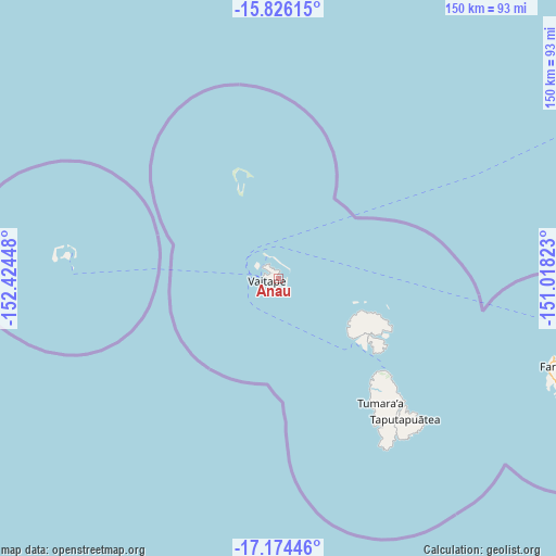
Anau GPS coordinates[2]
16° 30' 5.328" South, 151° 43' 16.86" West
| Map corner | latitude | longitude |
|---|---|---|
| Upper-left | -15.82615°, | -152.42448° |
| Center: | -16.50148°, | -151.72135° |
| Lower-right: | -17.17446°, | -151.01823° |
| Map W x H: | 149.9×149.9 km | = 93.1×93.1mi |
| max Lat: | -8.91093° ⇑7.7% North |
| Anau: | -16.50148° |
| min Lat: | ⇓92.3% South -23.34722° |
| min Long | Anau | max Long |
| -151.74913° | -151.72135° | -134.96858° |
| W 5.1%⇐ | ⇒94.9% E |
Elevation
Elevation of Anau is 8 m = 26 ft, and this is 14.6 m = 48 ft below average elevation for this country.
| Max E: |
245 m = 804 ft | 56.4% |
| Avg. | 22.6 m = 74 ft | |
| Anau | 8 m = 26 ft | |
Min E: |
1 m = 3 ft | 43.6% |
See also: French Polynesia elevation on elevation.city.
Geographical zone
Anau is located in South Torrid zone (between Equator and Tropic of Capricorn). Distance of this Southern Tropic circle is 771.1 km =479.1 mi to South.| Distance of | km | miles | from Anau |
|---|---|---|---|
| Equator | 1834.8 | 1140.1 | to North |
| Tropic Capricorn | 771.1 | 479.1 | to South |
| Antarctic Circle | 5566.4 | 3458.8 | to South |
| South Pole | 8172.3 | 5078 | to South |


Nearby cities:
15 places around Anau: (largest is in red/bold)
• Afareaitu
236.7 km =147.1 mi,  119°
119°
• Faaa
253.9 km =157.8 mi, 117°
• Faanui
2.7 km =1.7 mi,  307°
307°
• Fare
76.8 km =47.7 mi,  107°
107°
• Fitii
77.8 km =48.3 mi, 109°
• Haapiti
229.6 km =142.7 mi, 120°
• Haapu
82.3 km =51.1 mi, 113°
• Paopao
231.5 km =143.8 mi, 119°
• Papeete
256.4 km =159.3 mi, 116°
• Papetoai
225.3 km =140 mi, 119°
• Punaauia
258.2 km =160.4 mi, 119°
• Teavaro
235.6 km =146.4 mi, 118°
• Tevaitoa
40.6 km =25.2 mi,  142°
142°
• Uturoa
38.8 km =24.1 mi,  130°
130°
• Vaitape
3 km =1.9 mi,  257°
257°
Sources, notices
• [Note1] Compared only with cities in French Polynesia existing in our database
• [Src1] Map data: © OpenStreetMap contributors (CC-BY-SA)
• [Src2] Other city data from geonames.org with taken over terms of usage.
• [Src3] Geographical zone / Annual Mean Temperature by Robert A. Rohde @ Wikipedia
