Faanui geodata
Faanui is a populated place; located in French Polynesia in Pacific/Tahiti (GMT-10) time zone. With population of 2,061 people, there are 21 cities with bigger population in this country. Compared to other cities in French Polynesia, 94.9% of cities are located further ↓South; 97.4% of cities are located further →East and 51.3% of cities have higher elevation than Faanui. Note1


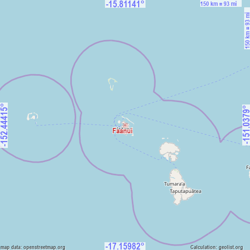
Faanui GPS coordinates[2]
16° 29' 12.444" South, 151° 44' 27.672" West
| Map corner | latitude | longitude |
|---|---|---|
| Upper-left | -15.81141°, | -152.44415° |
| Center: | -16.48679°, | -151.74102° |
| Lower-right: | -17.15982°, | -151.0379° |
| Map W x H: | 149.9×149.9 km | = 93.1×93.1mi |
| max Lat: | -8.91093° ⇑5.1% North |
| Faanui: | -16.48679° |
| min Lat: | ⇓94.9% South -23.34722° |
| min Long | Faanui | max Long |
| -151.74913° | -151.74102° | -134.96858° |
| W 2.6%⇐ | ⇒97.4% E |
Elevation
Elevation of Faanui is 9 m = 30 ft, and this is 13.6 m = 45 ft below average elevation for this country.
| Max E: |
245 m = 804 ft | 51.3% |
| Avg. | 22.6 m = 74 ft | |
| Faanui | 9 m = 30 ft | |
Min E: |
1 m = 3 ft | 48.7% |
See also: French Polynesia elevation on elevation.city.
Geographical zone
Faanui is located in South Torrid zone (between Equator and Tropic of Capricorn). Distance of this Southern Tropic circle is 772.8 km =480.2 mi to South.| Distance of | km | miles | from Faanui |
|---|---|---|---|
| Equator | 1833.2 | 1139.1 | to North |
| Tropic Capricorn | 772.8 | 480.2 | to South |
| Antarctic Circle | 5568 | 3459.8 | to South |
| South Pole | 8173.9 | 5079 | to South |


Nearby cities:
15 places around Faanui: (largest is in red/bold)
• Afareaitu
239.4 km =148.8 mi,  119°
119°
• Anau
2.7 km =1.7 mi,  127°
127°
• Faaa
256.5 km =159.4 mi, 117°
• Fare
79.3 km =49.3 mi,  108°
108°
• Fitii
80.4 km =50 mi, 110°
• Haapiti
232.3 km =144.3 mi, 121°
• Haapu
84.9 km =52.8 mi, 113°
• Paopao
234.1 km =145.5 mi, 119°
• Papeete
259 km =160.9 mi, 116°
• Papetoai
228 km =141.7 mi, 119°
• Punaauia
260.9 km =162.1 mi, 119°
• Teavaro
238.3 km =148.1 mi, 118°
• Tevaitoa
43.2 km =26.8 mi,  141°
141°
• Uturoa
41.5 km =25.8 mi, 130°
• Vaitape
2.5 km =1.6 mi,  200°
200°
Sources, notices
• [Note1] Compared only with cities in French Polynesia existing in our database
• [Src1] Map data: © OpenStreetMap contributors (CC-BY-SA)
• [Src2] Other city data from geonames.org with taken over terms of usage.
• [Src3] Geographical zone / Annual Mean Temperature by Robert A. Rohde @ Wikipedia
