Rabaul geodata
Rabaul (East New Britain) is a populated place; located in Papua New Guinea in Pacific/Port_Moresby (GMT+10) time zone. With population of 8,074 people, there are 21 cities with bigger population in this country. Compared to other cities in Papua New Guinea, 86.4% of cities are located further ↓South; 86.4% of cities are located further ←West and 52.3% of cities have higher elevation than Rabaul. Note1


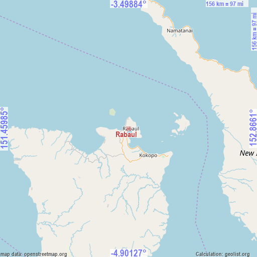
Rabaul GPS coordinates[2]
4° 12' 1.332" South, 152° 9' 46.692" East
| Map corner | latitude | longitude |
|---|---|---|
| Upper-left | -3.49884°, | 151.45985° |
| Center: | -4.20037°, | 152.16297° |
| Lower-right: | -4.90127°, | 152.8661° |
| Map W x H: | 155.9×155.9 km | = 96.9×96.9mi |
| max Lat: | -2.0341° ⇑13.6% North |
| Rabaul: | -4.20037° |
| min Lat: | ⇓86.4% South -10.61038° |
| min Long | Rabaul | max Long |
| 141.29061° | 152.16297° | 155.69147° |
| W 86.4%⇐ | ⇒13.6% E |
Elevation
Elevation of Rabaul is 39 m = 128 ft, and this is 542 m = 1778 ft below average elevation for this country.
| Max E: |
2248 m = 7375 ft | 52.3% |
| Avg. | 581 m = 1906 ft | |
| Rabaul | 39 m = 128 ft | |
Min E: |
0 m = 0 ft | 47.7% |
See also: Papua New Guinea elevation on elevation.city.
Geographical zone
Rabaul is located in South Torrid zone (between Equator and Tropic of Capricorn). Distance of Equator is 467 km =290.2 mi to North.| Distance of | km | miles | from Rabaul |
|---|---|---|---|
| Equator | 467 | 290.2 | to North |
| Tropic Capricorn | 2138.9 | 1329.1 | to South |
| Antarctic Circle | 6934.1 | 4308.6 | to South |
| South Pole | 9540 | 5927.9 | to South |


Nearby cities:
7 places around Rabaul: (largest is in red/bold)
• Arawa
439.2 km =272.9 mi,  120°
120°
• Buka
309.8 km =192.5 mi, 116°
• Kandrian
365.6 km =227.2 mi,  232°
232°
• Kavieng
236.2 km =146.8 mi,  319°
319°
• Kimbe
270 km =167.8 mi,  236°
236°
• Kokopo
19.7 km =12.2 mi,  143°
143°
• Panguna
436.6 km =271.3 mi, 122°
In other languages:
- In German: Simpson-Hafen, Rabaul, Simpsonhafen
- In Russian: Рабаул
- In Chinese: 拉包爾
Sources, notices
• [Note1] Compared only with cities in Papua New Guinea existing in our database
• [Src1] Map data: © OpenStreetMap contributors (CC-BY-SA)
• [Src2] Other city data from geonames.org with taken over terms of usage.
• [Src3] Geographical zone / Annual Mean Temperature by Robert A. Rohde @ Wikipedia
