Kandrian geodata
Kandrian (West New Britain) is a populated place; located in Papua New Guinea in Pacific/Port_Moresby (GMT+10) time zone. With population of 1,014 people, there are 36 cities with bigger population in this country. Compared to other cities in Papua New Guinea, 54.5% of cities are located further ↑North; 75% of cities are located further ←West and 97.7% of cities have higher elevation than Kandrian. Note1


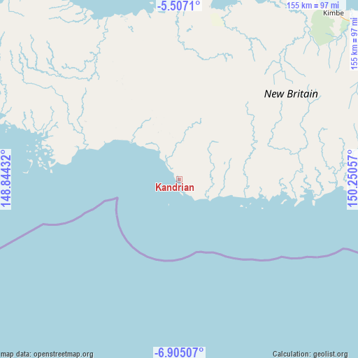
Kandrian GPS coordinates[2]
6° 12' 23.58" South, 149° 32' 50.784" East
| Map corner | latitude | longitude |
|---|---|---|
| Upper-left | -5.5071°, | 148.84432° |
| Center: | -6.20655°, | 149.54744° |
| Lower-right: | -6.90507°, | 150.25057° |
| Map W x H: | 155.4×155.4 km | = 96.6×96.6mi |
| max Lat: | -2.0341° ⇑54.5% North |
| Kandrian: | -6.20655° |
| min Lat: | ⇓45.5% South -10.61038° |
| min Long | Kandrian | max Long |
| 141.29061° | 149.54744° | 155.69147° |
| W 75%⇐ | ⇒25% E |
Elevation
Elevation of Kandrian is 1 m = 3 ft, and this is 580 m = 1903 ft below average elevation for this country.
| Max E: |
2248 m = 7375 ft | 97.7% |
| Avg. | 581 m = 1906 ft | |
| Kandrian | 1 m = 3 ft | |
Min E: |
0 m = 0 ft | 2.3% |
See also: Papua New Guinea elevation on elevation.city.
Geographical zone
Kandrian is located in South Torrid zone (between Equator and Tropic of Capricorn). Distance of Equator is 690.1 km =428.8 mi to North.| Distance of | km | miles | from Kandrian |
|---|---|---|---|
| Equator | 690.1 | 428.8 | to North |
| Tropic Capricorn | 1915.8 | 1190.4 | to South |
| Antarctic Circle | 6711.1 | 4170.1 | to South |
| South Pole | 9317 | 5789.3 | to South |


Nearby cities:
12 places around Kandrian: (largest is in red/bold)
• Bulolo
339.6 km =211 mi,  250°
250°
• Finschhafen
192 km =119.3 mi,  258°
258°
• Kainantu
407.1 km =253 mi,  268°
268°
• Kavieng
427 km =265.3 mi,  18°
18°
• Kimbe
97.9 km =60.8 mi,  41°
41°
• Kokoda
357.9 km =222.4 mi,  213°
213°
• Kokopo
365.6 km =227.2 mi,  55°
55°
• Lae
287.7 km =178.8 mi, 258°
• Madang
430.2 km =267.3 mi,  284°
284°
• Popondetta
319.3 km =198.4 mi, 206°
• Rabaul
365.6 km =227.2 mi,  52°
52°
• Wau
336.9 km =209.3 mi, 248°
Sources, notices
• [Note1] Compared only with cities in Papua New Guinea existing in our database
• [Src1] Map data: © OpenStreetMap contributors (CC-BY-SA)
• [Src2] Other city data from geonames.org with taken over terms of usage.
• [Src3] Geographical zone / Annual Mean Temperature by Robert A. Rohde @ Wikipedia
