Kimbe geodata
Kimbe (West New Britain) is a seat of a first-order administrative division; located in Papua New Guinea in Pacific/Port_Moresby (GMT+10) time zone. With population of 18,847 people, there are 8 cities with bigger population in this country. Compared to other cities in Papua New Guinea, 68.2% of cities are located further ↓South; 77.3% of cities are located further ←West and 59.1% of cities have higher elevation than Kimbe. Note1


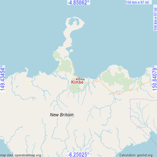
Kimbe GPS coordinates[2]
5° 33' 3.06" South, 150° 8' 15.576" East
| Map corner | latitude | longitude |
|---|---|---|
| Upper-left | -4.85062°, | 149.43454° |
| Center: | -5.55085°, | 150.13766° |
| Lower-right: | -6.25025°, | 150.84079° |
| Map W x H: | 155.6×155.6 km | = 96.7×96.7mi |
| max Lat: | -2.0341° ⇑31.8% North |
| Kimbe: | -5.55085° |
| min Lat: | ⇓68.2% South -10.61038° |
| min Long | Kimbe | max Long |
| 141.29061° | 150.13766° | 155.69147° |
| W 77.3%⇐ | ⇒22.7% E |
Elevation
Elevation of Kimbe is 27 m = 89 ft, and this is 554 m = 1818 ft below average elevation for this country.
| Max E: |
2248 m = 7375 ft | 59.1% |
| Avg. | 581 m = 1906 ft | |
| Kimbe | 27 m = 89 ft | |
Min E: |
0 m = 0 ft | 40.9% |
See also: Papua New Guinea elevation on elevation.city.
Geographical zone
Kimbe is located in South Torrid zone (between Equator and Tropic of Capricorn). Distance of Equator is 617.2 km =383.5 mi to North.| Distance of | km | miles | from Kimbe |
|---|---|---|---|
| Equator | 617.2 | 383.5 | to North |
| Tropic Capricorn | 1988.7 | 1235.7 | to South |
| Antarctic Circle | 6784 | 4215.4 | to South |
| South Pole | 9389.9 | 5834.6 | to South |


Nearby cities:
9 places around Kimbe: (largest is in red/bold)
• Bulolo
427.9 km =265.9 mi,  244°
244°
• Finschhafen
277 km =172.1 mi,  246°
246°
• Kandrian
97.9 km =60.8 mi,  221°
221°
• Kavieng
339 km =210.6 mi,  12°
12°
• Kokopo
271.6 km =168.8 mi,  60°
60°
• Lae
371 km =230.5 mi, 249°
• Popondetta
414.6 km =257.6 mi,  210°
210°
• Rabaul
270 km =167.8 mi, 56°
• Wau
427 km =265.3 mi, 242°
Sources, notices
• [Note1] Compared only with cities in Papua New Guinea existing in our database
• [Src1] Map data: © OpenStreetMap contributors (CC-BY-SA)
• [Src2] Other city data from geonames.org with taken over terms of usage.
• [Src3] Geographical zone / Annual Mean Temperature by Robert A. Rohde @ Wikipedia
