Villareal geodata
Villareal (Eastern Visayas) is a seat of a third-order administrative division; located in Philippines in Asia/Manila (GMT+8) time zone. With population of 3,765 people, there are 1874 cities with bigger population in this country. Compared to other cities in Philippines, 50.6% of cities are located further ↑North; 86.6% of cities are located further ←West and 73.2% of cities have higher elevation than Villareal. Note1


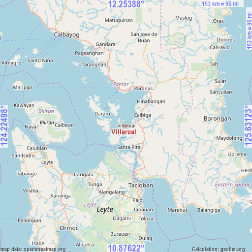
Villareal GPS coordinates[2]
11° 33' 57.24" North, 124° 55' 41.16" East
| Map corner | latitude | longitude |
|---|---|---|
| Upper-left | 12.25388°, | 124.22498° |
| Center: | 11.5659°, | 124.9281° |
| Lower-right: | 10.87622°, | 125.63123° |
| Map W x H: | 153.2×153.2 km | = 95.2×95.2mi |
| max Lat: | 20.78733° ⇑50.6% North |
| Villareal: | 11.5659° |
| min Lat: | ⇓49.4% South 4.65442° |
| min Long | Villareal | max Long |
| 117.04868° | 124.9281° | 126.58417° |
| W 86.6%⇐ | ⇒13.4% E |
Elevation
Elevation of Villareal is 11 m = 36 ft, and this is 76.9 m = 252 ft below average elevation for this country.
| Max E: |
2262 m = 7421 ft | 73.2% |
| Avg. | 87.9 m = 288 ft | |
| Villareal | 11 m = 36 ft | |
Min E: |
-2 m = -7 ft | 26.8% |
See also: Philippines elevation on elevation.city.
Geographical zone
Villareal is located in North Torrid zone (between Equator and Tropic of Cancer). Distance of Equator is 1286 km =799.1 mi to South.| Distance of | km | miles | from Villareal |
|---|---|---|---|
| North Pole | 8721.1 | 5419 | to North |
| Arctic Circle | 6115.2 | 3799.8 | to North |
| Tropic Cancer | 1319.9 | 820.1 | to North |
| Equator | 1286 | 799.1 | to South |


Nearby cities:
15 places around Villareal: (largest is in red/bold)
• Babatngon
18.2 km =11.3 mi,  209°
209°
• Calbiga
11.6 km =7.2 mi,  55°
55°
• Catbalogan
23.7 km =14.7 mi,  348°
348°
• Daram
16.4 km =10.2 mi,  297°
297°
• Guirang
31.6 km =19.6 mi,  139°
139°
• Jiabong
22 km =13.7 mi,  6°
6°
• Mabini
30.8 km =19.1 mi,  122°
122°
• Motiong
25.1 km =15.6 mi,  18°
18°
• Pangdan
19.9 km =12.4 mi,  356°
356°
• San Sebastian
18.8 km =11.7 mi,  31°
31°
• Santa Rita
13 km =8.1 mi,  173°
173°
• Silanga
29.5 km =18.3 mi,  341°
341°
• Talalora
10.8 km =6.7 mi,  247°
247°
• Wright
24.9 km =15.5 mi, 24°
• Zumarraga
12.4 km =7.7 mi,  310°
310°
Sources, notices
• [Note1] Compared only with cities in Philippines existing in our database
• [Src1] Map data: © OpenStreetMap contributors (CC-BY-SA)
• [Src2] Other city data from geonames.org with taken over terms of usage.
• [Src3] Geographical zone / Annual Mean Temperature by Robert A. Rohde @ Wikipedia
