Talalora geodata
Talalora (Eastern Visayas) is a seat of a third-order administrative division; located in Philippines in Asia/Manila (GMT+8) time zone. With population of 2,186 people, there are 3915 cities with bigger population in this country. Compared to other cities in Philippines, 51.1% of cities are located further ↑North; 85.2% of cities are located further ←West and 95.5% of cities have higher elevation than Talalora. Note1


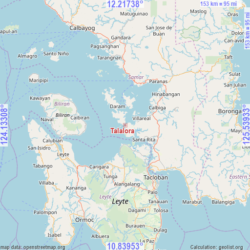
Talalora GPS coordinates[2]
11° 31' 45.48" North, 124° 50' 10.32" East
| Map corner | latitude | longitude |
|---|---|---|
| Upper-left | 12.21738°, | 124.13308° |
| Center: | 11.5293°, | 124.8362° |
| Lower-right: | 10.83953°, | 125.53933° |
| Map W x H: | 153.2×153.2 km | = 95.2×95.2mi |
| max Lat: | 20.78733° ⇑51.1% North |
| Talalora: | 11.5293° |
| min Lat: | ⇓48.9% South 4.65442° |
| min Long | Talalora | max Long |
| 117.04868° | 124.8362° | 126.58417° |
| W 85.2%⇐ | ⇒14.8% E |
Elevation
Elevation of Talalora is 5 m = 16 ft, and this is 82.9 m = 272 ft below average elevation for this country.
| Max E: |
2262 m = 7421 ft | 95.5% |
| Avg. | 87.9 m = 288 ft | |
| Talalora | 5 m = 16 ft | |
Min E: |
-2 m = -7 ft | 4.5% |
See also: Philippines elevation on elevation.city.
Geographical zone
Talalora is located in North Torrid zone (between Equator and Tropic of Cancer). Distance of Equator is 1281.9 km =796.5 mi to South.| Distance of | km | miles | from Talalora |
|---|---|---|---|
| North Pole | 8725.1 | 5421.5 | to North |
| Arctic Circle | 6119.2 | 3802.3 | to North |
| Tropic Cancer | 1324 | 822.7 | to North |
| Equator | 1281.9 | 796.5 | to South |


Nearby cities:
15 places around Talalora: (largest is in red/bold)
• Babatngon
11.8 km =7.3 mi,  175°
175°
• Barugo
25.2 km =15.7 mi,  205°
205°
• Bunga
27.1 km =16.8 mi,  259°
259°
• Caibiran
28.1 km =17.5 mi,  279°
279°
• Calbiga
22.3 km =13.9 mi,  61°
61°
• Catbalogan
27.9 km =17.3 mi,  11°
11°
• Daram
12.5 km =7.8 mi,  338°
338°
• Guindapunan
28.9 km =18 mi, 209°
• Jiabong
28.8 km =17.9 mi,  25°
25°
• Pangdan
25.5 km =15.8 mi,  20°
20°
• San Miguel
29.1 km =18.1 mi, 180°
• San Sebastian
28.2 km =17.5 mi,  44°
44°
• Santa Rita
14.5 km =9 mi,  127°
127°
• Villareal
10.8 km =6.7 mi,  67°
67°
• Zumarraga
12.2 km =7.6 mi,  2°
2°
Sources, notices
• [Note1] Compared only with cities in Philippines existing in our database
• [Src1] Map data: © OpenStreetMap contributors (CC-BY-SA)
• [Src2] Other city data from geonames.org with taken over terms of usage.
• [Src3] Geographical zone / Annual Mean Temperature by Robert A. Rohde @ Wikipedia
