Santa Rita geodata
Santa Rita (Eastern Visayas) is a seat of a third-order administrative division; located in Philippines in Asia/Manila (GMT+8) time zone. With population of 4,338 people, there are 1567 cities with bigger population in this country. Compared to other cities in Philippines, 52% of cities are located further ↑North; 86.7% of cities are located further ←West and 95.5% of cities have higher elevation than Santa Rita. Note1


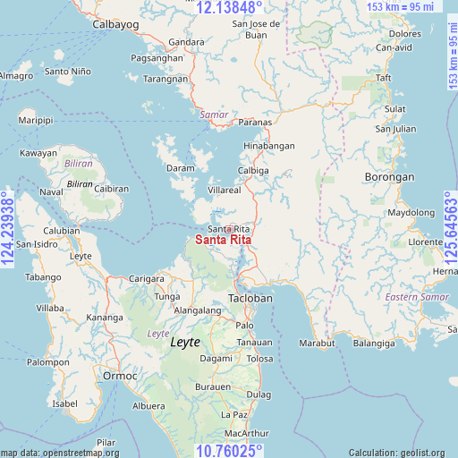
Santa Rita GPS coordinates[2]
11° 27' 0.72" North, 124° 56' 33" East
| Map corner | latitude | longitude |
|---|---|---|
| Upper-left | 12.13848°, | 124.23938° |
| Center: | 11.4502°, | 124.9425° |
| Lower-right: | 10.76025°, | 125.64563° |
| Map W x H: | 153.2×153.2 km | = 95.2×95.2mi |
| max Lat: | 20.78733° ⇑52% North |
| Santa Rita: | 11.4502° |
| min Lat: | ⇓48% South 4.65442° |
| min Long | Santa Rita | max Long |
| 117.04868° | 124.9425° | 126.58417° |
| W 86.7%⇐ | ⇒13.3% E |
Elevation
Elevation of Santa Rita is 5 m = 16 ft, and this is 82.9 m = 272 ft below average elevation for this country.
| Max E: |
2262 m = 7421 ft | 95.5% |
| Avg. | 87.9 m = 288 ft | |
| Santa Rita | 5 m = 16 ft | |
Min E: |
-2 m = -7 ft | 4.5% |
See also: Philippines elevation on elevation.city.
Geographical zone
Santa Rita is located in North Torrid zone (between Equator and Tropic of Cancer). Distance of Equator is 1273.1 km =791.1 mi to South.| Distance of | km | miles | from Santa Rita |
|---|---|---|---|
| North Pole | 8733.9 | 5427 | to North |
| Arctic Circle | 6128 | 3807.8 | to North |
| Tropic Cancer | 1332.8 | 828.2 | to North |
| Equator | 1273.1 | 791.1 | to South |


Nearby cities:
15 places around Santa Rita: (largest is in red/bold)
• Alangalang
29.1 km =18.1 mi,  201°
201°
• Babatngon
11 km =6.8 mi,  254°
254°
• Barugo
26.3 km =16.3 mi,  237°
237°
• Basey
23.3 km =14.5 mi,  143°
143°
• Calbiga
21 km =13 mi,  22°
22°
• Daram
26 km =16.2 mi,  321°
321°
• Guirang
22 km =13.7 mi,  120°
120°
• Mabini
24.7 km =15.3 mi,  98°
98°
• Panalanoy
23.2 km =14.4 mi,  162°
162°
• San Antonio
20.7 km =12.9 mi, 158°
• San Miguel
23.6 km =14.7 mi,  210°
210°
• Tacloban
24 km =14.9 mi, 163°
• Talalora
14.5 km =9 mi,  307°
307°
• Villareal
13 km =8.1 mi,  353°
353°
• Zumarraga
23.7 km =14.7 mi,  332°
332°
Sources, notices
• [Note1] Compared only with cities in Philippines existing in our database
• [Src1] Map data: © OpenStreetMap contributors (CC-BY-SA)
• [Src2] Other city data from geonames.org with taken over terms of usage.
• [Src3] Geographical zone / Annual Mean Temperature by Robert A. Rohde @ Wikipedia
