Mabini geodata
Mabini (Eastern Visayas) is a populated place; located in Philippines in Asia/Manila (GMT+8) time zone. With population of 2,130 people, there are 4030 cities with bigger population in this country. Compared to other cities in Philippines, 52.4% of cities are located further ↑North; 89.9% of cities are located further ←West and 85.3% of cities have lower elevation than Mabini. Note1


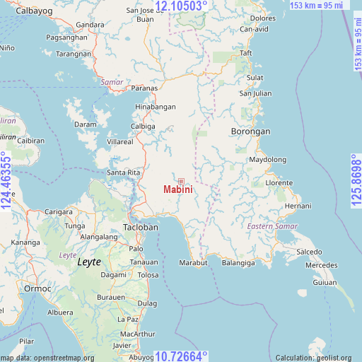
Mabini GPS coordinates[2]
11° 25' 0.012" North, 125° 10' 0.012" East
| Map corner | latitude | longitude |
|---|---|---|
| Upper-left | 12.10503°, | 124.46355° |
| Center: | 11.41667°, | 125.16667° |
| Lower-right: | 10.72664°, | 125.8698° |
| Map W x H: | 153.3×153.3 km | = 95.3×95.3mi |
| max Lat: | 20.78733° ⇑52.4% North |
| Mabini: | 11.41667° |
| min Lat: | ⇓47.6% South 4.65442° |
| min Long | Mabini | max Long |
| 117.04868° | 125.16667° | 126.58417° |
| W 89.9%⇐ | ⇒10.1% E |
Elevation
Elevation of Mabini is 142 m = 466 ft, and this is 54.1 m = 177 ft above average elevation for this country.
| Max E: |
2262 m = 7421 ft | 14.7% |
| Mabini | 142 m 466 ft | |
| Avg. | 87.9 m = 288 ft | |
Min E: |
-2 m = -7 ft | 85.3% |
See also: Philippines elevation on elevation.city.
Geographical zone
Mabini is located in North Torrid zone (between Equator and Tropic of Cancer). Distance of Equator is 1269.4 km =788.8 mi to South.| Distance of | km | miles | from Mabini |
|---|---|---|---|
| North Pole | 8737.6 | 5429.3 | to North |
| Arctic Circle | 6131.8 | 3810.1 | to North |
| Tropic Cancer | 1336.5 | 830.5 | to North |
| Equator | 1269.4 | 788.8 | to South |


Nearby cities:
15 places around Mabini: (largest is in red/bold)
• Babatngon
35.1 km =21.8 mi,  271°
271°
• Baras
30.7 km =19.1 mi,  212°
212°
• Basey
18.3 km =11.4 mi,  215°
215°
• Borongan
35.9 km =22.3 mi,  53°
53°
• Cabay
35.7 km =22.2 mi,  84°
84°
• Calbiga
28.3 km =17.6 mi,  324°
324°
• Guirang
9.2 km =5.7 mi, 216°
• Lawa-an
34.1 km =21.2 mi,  154°
154°
• Palo
34.6 km =21.5 mi, 213°
• Panalanoy
25.4 km =15.8 mi, 223°
• Pawing
31.8 km =19.8 mi, 214°
• San Antonio
23 km =14.3 mi,  227°
227°
• Santa Rita
24.7 km =15.3 mi,  278°
278°
• Tacloban
26.1 km =16.2 mi, 222°
• Villareal
30.8 km =19.1 mi,  302°
302°
Sources, notices
• [Note1] Compared only with cities in Philippines existing in our database
• [Src1] Map data: © OpenStreetMap contributors (CC-BY-SA)
• [Src2] Other city data from geonames.org with taken over terms of usage.
• [Src3] Geographical zone / Annual Mean Temperature by Robert A. Rohde @ Wikipedia
