Naujan geodata
Naujan (Mimaropa) is a populated place; located in Philippines in Asia/Manila (GMT+8) time zone. With population of 2,792 people, there are 2801 cities with bigger population in this country. Compared to other cities in Philippines, 60.4% of cities are located further ↓South; 70.2% of cities are located further →East and 80.7% of cities have higher elevation than Naujan. Note1


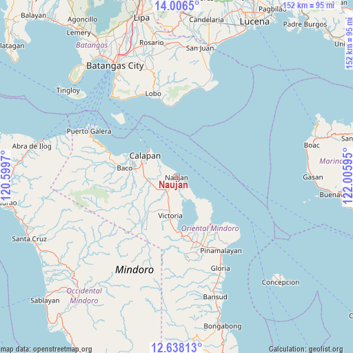
Naujan GPS coordinates[2]
13° 19' 23.808" North, 121° 18' 10.152" East
| Map corner | latitude | longitude |
|---|---|---|
| Upper-left | 14.0065°, | 120.5997° |
| Center: | 13.32328°, | 121.30282° |
| Lower-right: | 12.63813°, | 122.00595° |
| Map W x H: | 152.1×152.2 km | = 94.5×94.6mi |
| max Lat: | 20.78733° ⇑39.6% North |
| Naujan: | 13.32328° |
| min Lat: | ⇓60.4% South 4.65442° |
| min Long | Naujan | max Long |
| 117.04868° | 121.30282° | 126.58417° |
| W 29.8%⇐ | ⇒70.2% E |
Elevation
Elevation of Naujan is 9 m = 30 ft, and this is 78.9 m = 259 ft below average elevation for this country.
| Max E: |
2262 m = 7421 ft | 80.7% |
| Avg. | 87.9 m = 288 ft | |
| Naujan | 9 m = 30 ft | |
Min E: |
-2 m = -7 ft | 19.3% |
See also: Philippines elevation on elevation.city.
Geographical zone
Naujan is located in North Torrid zone (between Equator and Tropic of Cancer). Distance of this Northern Tropic circle is 1124.5 km =698.7 mi to North.| Distance of | km | miles | from Naujan |
|---|---|---|---|
| North Pole | 8525.7 | 5297.6 | to North |
| Arctic Circle | 5919.8 | 3678.4 | to North |
| Tropic Cancer | 1124.5 | 698.7 | to North |
| Equator | 1481.4 | 920.5 | to South |


Nearby cities:
15 places around Naujan: (largest is in red/bold)
• Apitong
13.9 km =8.6 mi,  227°
227°
• Bayanan
14.9 km =9.3 mi,  285°
285°
• Biga
15.4 km =9.6 mi,  264°
264°
• Calapan
16.5 km =10.3 mi,  306°
306°
• Canubing No 2
18.6 km =11.6 mi,  279°
279°
• Communal
19.5 km =12.1 mi,  247°
247°
• Dulangan
20.6 km =12.8 mi, 264°
• Estrella
1.1 km =0.7 mi,  54°
54°
• Manogpi
10.8 km =6.7 mi, 262°
• Nagiba
3.2 km =2 mi, 283°
• Pinagsabangan
7.4 km =4.6 mi,  210°
210°
• San Agustin
5.1 km =3.2 mi,  177°
177°
• San Vincente
16.7 km =10.4 mi,  303°
303°
• Sapol
13.1 km =8.1 mi, 290°
• Victoria
16.5 km =10.3 mi,  189°
189°
Sources, notices
• [Note1] Compared only with cities in Philippines existing in our database
• [Src1] Map data: © OpenStreetMap contributors (CC-BY-SA)
• [Src2] Other city data from geonames.org with taken over terms of usage.
• [Src3] Geographical zone / Annual Mean Temperature by Robert A. Rohde @ Wikipedia
